Pasturo geodata
Pasturo (Lombardy) is a seat of a third-order administrative division; located in Italy in Europe/Rome (GMT+2) time zone. With population of 1,911 people, there are 4301 cities with bigger population in this country. Compared to other cities in Italy, 90.7% of cities are located further ↓South; 73.9% of cities are located further →East and 85.1% of cities have lower elevation than Pasturo. Note1


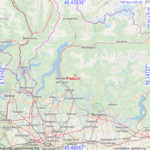
Pasturo GPS coordinates[2]
45° 57' 6.048" North, 9° 26' 38.904" East
| Map corner | latitude | longitude |
|---|---|---|
| Upper-left | 46.43838°, | 8.74102° |
| Center: | 45.95168°, | 9.44414° |
| Lower-right: | 45.46067°, | 10.14727° |
| Map W x H: | 108.7×108.7 km | = 67.5×67.5mi |
| max Lat: | 47.04031° ⇑9.3% North |
| Pasturo: | 45.95168° |
| min Lat: | ⇓90.7% South 35.50142° |
| min Long | Pasturo | max Long |
| 6.69888° | 9.44414° | 18.48682° |
| W 26.1%⇐ | ⇒73.9% E |
Elevation
Elevation of Pasturo is 614 m = 2014 ft, and this is 307.3 m = 1008 ft above average elevation for this country.
| Max E: |
2085 m = 6841 ft | 14.9% |
| Pasturo | 614 m 2014 ft | |
| Avg. | 306.7 m = 1006 ft | |
Min E: |
-4 m = -13 ft | 85.1% |
See also: Italy elevation on elevation.city.
Geographical zone
Pasturo is located in North temperate zone (between Tropic of Cancer and the Arctic Circle). Distance of this North polar circle is 2291.8 km =1424.1 mi to North.| Distance of | km | miles | from Pasturo |
|---|---|---|---|
| North Pole | 4897.7 | 3043.3 | to North |
| Arctic Circle | 2291.8 | 1424.1 | to North |
| Tropic Cancer | 2503.4 | 1555.5 | to South |
| Equator | 5109.3 | 3174.8 | to South |


Nearby cities:
15 places around Pasturo: (largest is in red/bold)
• Ballabio
6.4 km =4 mi,  194°
194°
• Barzio
2 km =1.2 mi,  117°
117°
• Cassina Valsassina
3.5 km =2.2 mi,  128°
128°
• Cortenova
7.1 km =4.4 mi,  319°
319°
• Crandola Valsassina
9.4 km =5.8 mi,  327°
327°
• Crebbio
9.6 km =6 mi,  243°
243°
• Cremeno
2.8 km =1.7 mi, 131°
• Esino Lario
9.7 km =6 mi,  299°
299°
• Introbio
2.5 km =1.6 mi,  10°
10°
• Maggio
3.1 km =1.9 mi,  157°
157°
• Moggio
3.9 km =2.4 mi, 123°
• Morterone
9 km =5.6 mi, 160°
• Primaluna
3.6 km =2.2 mi,  351°
351°
• Valtorta
7.5 km =4.7 mi,  68°
68°
• Vedeseta
10 km =6.2 mi, 132°
Sources, notices
• [Note1] Compared only with cities in Italy existing in our database
• [Src1] Map data: © OpenStreetMap contributors (CC-BY-SA)
• [Src2] Other city data from geonames.org with taken over terms of usage.
• [Src3] Geographical zone / Annual Mean Temperature by Robert A. Rohde @ Wikipedia
