Macere geodata
Macere (Latium) is a populated place; located in Italy in Europe/Rome (GMT+2) time zone. With population of 1,619 people, there are 4853 cities with bigger population in this country. Compared to other cities in Italy, 72.4% of cities are located further ↑North; 66.7% of cities are located further ←West and 61.3% of cities have lower elevation than Macere. Note1
Administrative division(s):
- Level 1: Latium
- Level 2: Città metropolitana di Roma Capitale
- Level 3: Artena


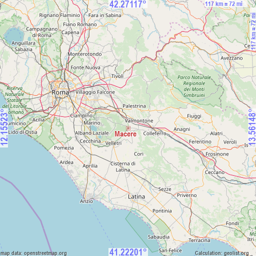
Macere GPS coordinates[2]
41° 44' 55.428" North, 12° 51' 30.06" East
| Map corner | latitude | longitude |
|---|---|---|
| Upper-left | 42.27117°, | 12.15523° |
| Center: | 41.74873°, | 12.85835° |
| Lower-right: | 41.22201°, | 13.56148° |
| Map W x H: | 116.7×116.7 km | = 72.5×72.5mi |
| max Lat: | 47.04031° ⇑72.4% North |
| Macere: | 41.74873° |
| min Lat: | ⇓27.6% South 35.50142° |
| min Long | Macere | max Long |
| 6.69888° | 12.85835° | 18.48682° |
| W 66.7%⇐ | ⇒33.3% E |
Elevation
Elevation of Macere is 309 m = 1014 ft, and this is 2.3 m = 8 ft above average elevation for this country.
| Max E: |
2085 m = 6841 ft | 38.7% |
| Macere | 309 m 1014 ft | |
| Avg. | 306.7 m = 1006 ft | |
Min E: |
-4 m = -13 ft | 61.3% |
See also: Italy elevation on elevation.city.
Geographical zone
Macere is located in North temperate zone (between Tropic of Cancer and the Arctic Circle). Distance of this Northern Tropic circle is 2036.1 km =1265.2 mi to South.| Distance of | km | miles | from Macere |
|---|---|---|---|
| North Pole | 5365 | 3333.7 | to North |
| Arctic Circle | 2759.2 | 1714.5 | to North |
| Tropic Cancer | 2036.1 | 1265.2 | to South |
| Equator | 4642 | 2884.4 | to South |


Nearby cities:
15 places around Macere: (largest is in red/bold)
• Artena
4.1 km =2.5 mi,  101°
101°
• Carchitti
4.9 km =3 mi,  330°
330°
• Colle Spina
3.8 km =2.4 mi,  346°
346°
• Colle di Fuori
7.2 km =4.5 mi,  323°
323°
• Colubro
1.7 km =1.1 mi,  154°
154°
• Cruci
8.5 km =5.3 mi,  60°
60°
• Giulianello
7.2 km =4.5 mi,  166°
166°
• Labico
5 km =3.1 mi,  12°
12°
• Lariano
4.2 km =2.6 mi,  216°
216°
• Rocca Massima
9.3 km =5.8 mi, 146°
• Rocca Priora
7.9 km =4.9 mi,  283°
283°
• San Bartolomeo
8.8 km =5.5 mi,  33°
33°
• San Cesareo
9.2 km =5.7 mi, 330°
• Valmontone
5.7 km =3.5 mi, 61°
• Via Latina Iv Km
8.7 km =5.4 mi, 100°
Sources, notices
• [Note1] Compared only with cities in Italy existing in our database
• [Src1] Map data: © OpenStreetMap contributors (CC-BY-SA)
• [Src2] Other city data from geonames.org with taken over terms of usage.
• [Src3] Geographical zone / Annual Mean Temperature by Robert A. Rohde @ Wikipedia
