Via Latina Iv Km geodata
Via Latina Iv Km (Latium) is a populated place; located in Italy in Europe/Rome (GMT+2) time zone. With population of 755 people, there are 7914 cities with bigger population in this country. Compared to other cities in Italy, 72.5% of cities are located further ↑North; 67.8% of cities are located further ←West and 50.3% of cities have higher elevation than Via Latina Iv Km. Note1
Administrative division(s):
- Level 1: Latium
- Level 2: Città metropolitana di Roma Capitale
- Level 3: Colleferro


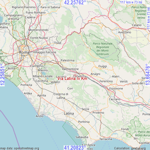
Via Latina Iv Km GPS coordinates[2]
41° 44' 6.252" North, 12° 57' 41.868" East
| Map corner | latitude | longitude |
|---|---|---|
| Upper-left | 42.25762°, | 12.25851° |
| Center: | 41.73507°, | 12.96163° |
| Lower-right: | 41.20823°, | 13.66476° |
| Map W x H: | 116.7×116.7 km | = 72.5×72.5mi |
| max Lat: | 47.04031° ⇑72.5% North |
| Via Latina Iv Km: | 41.73507° |
| min Lat: | ⇓27.5% South 35.50142° |
| min Long | Via Latina Iv K | max Long |
| 6.69888° | 12.96163° | 18.48682° |
| W 67.8%⇐ | ⇒32.2% E |
Elevation
Elevation of Via Latina Iv Km is 233 m = 764 ft, and this is 73.7 m = 242 ft below average elevation for this country.
| Max E: |
2085 m = 6841 ft | 50.3% |
| Avg. | 306.7 m = 1006 ft | |
| Via Latina Iv Km | 233 m = 764 ft | |
Min E: |
-4 m = -13 ft | 49.7% |
See also: Italy elevation on elevation.city.
Geographical zone
Via Latina Iv Km is located in North temperate zone (between Tropic of Cancer and the Arctic Circle). Distance of this Northern Tropic circle is 2034.6 km =1264.2 mi to South.| Distance of | km | miles | from Via Latina Iv Km |
|---|---|---|---|
| North Pole | 5366.6 | 3334.6 | to North |
| Arctic Circle | 2760.7 | 1715.4 | to North |
| Tropic Cancer | 2034.6 | 1264.2 | to South |
| Equator | 4640.5 | 2883.5 | to South |


Nearby cities:
15 places around Via Latina Iv Km: (largest is in red/bold)
• Artena
4.6 km =2.9 mi,  278°
278°
• Cave
9.3 km =5.8 mi,  349°
349°
• Colleferro
3.7 km =2.3 mi,  103°
103°
• Colubro
7.8 km =4.8 mi,  269°
269°
• Cruci
5.8 km =3.6 mi, 348°
• Gavignano
8.4 km =5.2 mi,  118°
118°
• Genazzano
10.4 km =6.5 mi,  4°
4°
• Giulianello
8.7 km =5.4 mi,  231°
231°
• Labico
9.9 km =6.2 mi,  310°
310°
• Macere
8.7 km =5.4 mi, 280°
• Paliano
10.8 km =6.7 mi,  62°
62°
• Rocca Massima
7.1 km =4.4 mi,  208°
208°
• San Bartolomeo
9.5 km =5.9 mi,  337°
337°
• Segni
7 km =4.3 mi,  136°
136°
• Valmontone
5.5 km =3.4 mi,  319°
319°
Sources, notices
• [Note1] Compared only with cities in Italy existing in our database
• [Src1] Map data: © OpenStreetMap contributors (CC-BY-SA)
• [Src2] Other city data from geonames.org with taken over terms of usage.
• [Src3] Geographical zone / Annual Mean Temperature by Robert A. Rohde @ Wikipedia
