Capitello geodata
Capitello (Veneto) is a seat of a third-order administrative division; located in Italy in Europe/Rome (GMT+2) time zone. With population of 750 people, there are 7955 cities with bigger population in this country. Compared to other cities in Italy, 65.1% of cities are located further ↓South; 55.3% of cities are located further →East and 88.7% of cities have higher elevation than Capitello. Note1


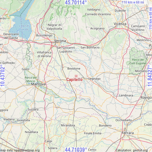
Capitello GPS coordinates[2]
45° 12' 28.512" North, 11° 8' 24.504" East
| Map corner | latitude | longitude |
|---|---|---|
| Upper-left | 45.70114°, | 10.43702° |
| Center: | 45.20792°, | 11.14014° |
| Lower-right: | 44.71039°, | 11.84327° |
| Map W x H: | 110.2×110.2 km | = 68.5×68.5mi |
| max Lat: | 47.04031° ⇑34.9% North |
| Capitello: | 45.20792° |
| min Lat: | ⇓65.1% South 35.50142° |
| min Long | Capitello | max Long |
| 6.69888° | 11.14014° | 18.48682° |
| W 44.7%⇐ | ⇒55.3% E |
Elevation
Elevation of Capitello is 21 m = 69 ft, and this is 285.7 m = 937 ft below average elevation for this country.
| Max E: |
2085 m = 6841 ft | 88.7% |
| Avg. | 306.7 m = 1006 ft | |
| Capitello | 21 m = 69 ft | |
Min E: |
-4 m = -13 ft | 11.3% |
See also: Italy elevation on elevation.city.
Geographical zone
Capitello is located in North temperate zone (between Tropic of Cancer and the Arctic Circle). Distance of this North polar circle is 2374.5 km =1475.4 mi to North.| Distance of | km | miles | from Capitello |
|---|---|---|---|
| North Pole | 4980.4 | 3094.7 | to North |
| Arctic Circle | 2374.5 | 1475.4 | to North |
| Tropic Cancer | 2420.7 | 1504.2 | to South |
| Equator | 5026.6 | 3123.4 | to South |


Nearby cities:
15 places around Capitello: (largest is in red/bold)
• Asparetto
3.6 km =2.2 mi,  68°
68°
• Bionde
3.3 km =2.1 mi,  254°
254°
• Bonavicina
5.3 km =3.3 mi,  40°
40°
• Bovolone
6.2 km =3.9 mi,  343°
343°
• Casaleone
6.1 km =3.8 mi,  136°
136°
• Cerea
6.3 km =3.9 mi,  109°
109°
• Maccacari
7.3 km =4.5 mi,  183°
183°
• Nogara
6.9 km =4.3 mi,  244°
244°
• Pellegrina
9.7 km =6 mi,  283°
283°
• Piazza
0.9 km =0.6 mi,  11°
11°
• Roncanova
7.8 km =4.8 mi,  201°
201°
• Salizzole
5 km =3.1 mi,  315°
315°
• San Pietro di Morubio
7.8 km =4.8 mi,  60°
60°
• Sanguinetto
2.5 km =1.6 mi,  172°
172°
• Tarmassia
9.6 km =6 mi, 316°
Sources, notices
• [Note1] Compared only with cities in Italy existing in our database
• [Src1] Map data: © OpenStreetMap contributors (CC-BY-SA)
• [Src2] Other city data from geonames.org with taken over terms of usage.
• [Src3] Geographical zone / Annual Mean Temperature by Robert A. Rohde @ Wikipedia
