Cerea geodata
Cerea (Veneto) is a seat of a third-order administrative division; located in Italy in Europe/Rome (GMT+2) time zone. With population of 12,869 people, there are 714 cities with bigger population in this country. Compared to other cities in Italy, 64.7% of cities are located further ↓South; 54.3% of cities are located further →East and 90.6% of cities have higher elevation than Cerea. Note1


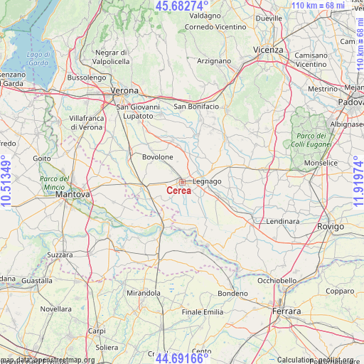
Cerea GPS coordinates[2]
45° 11' 21.696" North, 11° 12' 59.796" East
| Map corner | latitude | longitude |
|---|---|---|
| Upper-left | 45.68274°, | 10.51349° |
| Center: | 45.18936°, | 11.21661° |
| Lower-right: | 44.69166°, | 11.91974° |
| Map W x H: | 110.2×110.2 km | = 68.5×68.5mi |
| max Lat: | 47.04031° ⇑35.3% North |
| Cerea: | 45.18936° |
| min Lat: | ⇓64.7% South 35.50142° |
| min Long | Cerea | max Long |
| 6.69888° | 11.21661° | 18.48682° |
| W 45.7%⇐ | ⇒54.3% E |
Elevation
Elevation of Cerea is 17 m = 56 ft, and this is 289.7 m = 950 ft below average elevation for this country.
| Max E: |
2085 m = 6841 ft | 90.6% |
| Avg. | 306.7 m = 1006 ft | |
| Cerea | 17 m = 56 ft | |
Min E: |
-4 m = -13 ft | 9.4% |
See also: Italy elevation on elevation.city.
Geographical zone
Cerea is located in North temperate zone (between Tropic of Cancer and the Arctic Circle). Distance of this North polar circle is 2376.6 km =1476.8 mi to North.| Distance of | km | miles | from Cerea |
|---|---|---|---|
| North Pole | 4982.5 | 3096 | to North |
| Arctic Circle | 2376.6 | 1476.8 | to North |
| Tropic Cancer | 2418.7 | 1502.9 | to South |
| Equator | 5024.6 | 3122.1 | to South |


Nearby cities:
15 places around Cerea: (largest is in red/bold)
• Angiari
6 km =3.7 mi,  51°
51°
• Asparetto
4.3 km =2.7 mi,  321°
321°
• Bionde
9.2 km =5.7 mi,  277°
277°
• Bonavicina
6.6 km =4.1 mi,  337°
337°
• Bonavigo
9.1 km =5.7 mi,  32°
32°
• Capitello
6.3 km =3.9 mi,  289°
289°
• Casaleone
2.9 km =1.8 mi,  216°
216°
• Gallese
9.8 km =6.1 mi,  66°
66°
• Legnago
6.7 km =4.2 mi,  85°
85°
• Maccacari
8.2 km =5.1 mi,  231°
231°
• Piazza
6.5 km =4 mi,  296°
296°
• Roverchiara
9 km =5.6 mi,  14°
14°
• Roverchiaretta
8.4 km =5.2 mi,  24°
24°
• San Pietro di Morubio
6 km =3.7 mi, 7°
• Sanguinetto
5.7 km =3.5 mi,  265°
265°
Sources, notices
• [Note1] Compared only with cities in Italy existing in our database
• [Src1] Map data: © OpenStreetMap contributors (CC-BY-SA)
• [Src2] Other city data from geonames.org with taken over terms of usage.
• [Src3] Geographical zone / Annual Mean Temperature by Robert A. Rohde @ Wikipedia
