Luzzara geodata
Luzzara (Emilia-Romagna) is a seat of a third-order administrative division; located in Italy in Europe/Rome (GMT+2) time zone. With population of 4,383 people, there are 2197 cities with bigger population in this country. Compared to other cities in Italy, 59.1% of cities are located further ↓South; 61.1% of cities are located further →East and 87.8% of cities have higher elevation than Luzzara. Note1
Administrative division(s):
- Level 1: Emilia-Romagna
- Level 2: Provincia di Reggio Emilia
- Level 3: Luzzara


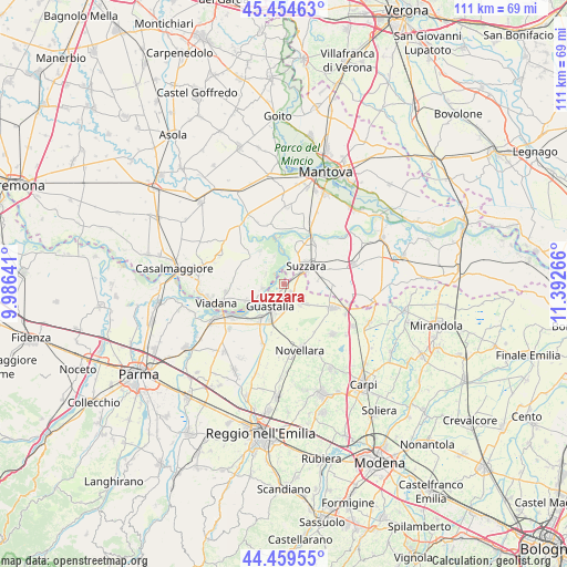
Luzzara GPS coordinates[2]
44° 57' 33.3" North, 10° 41' 22.308" East
| Map corner | latitude | longitude |
|---|---|---|
| Upper-left | 45.45463°, | 9.98641° |
| Center: | 44.95925°, | 10.68953° |
| Lower-right: | 44.45955°, | 11.39266° |
| Map W x H: | 110.6×110.6 km | = 68.7×68.7mi |
| max Lat: | 47.04031° ⇑40.9% North |
| Luzzara: | 44.95925° |
| min Lat: | ⇓59.1% South 35.50142° |
| min Long | Luzzara | max Long |
| 6.69888° | 10.68953° | 18.48682° |
| W 38.9%⇐ | ⇒61.1% E |
Elevation
Elevation of Luzzara is 23 m = 75 ft, and this is 283.7 m = 931 ft below average elevation for this country.
| Max E: |
2085 m = 6841 ft | 87.8% |
| Avg. | 306.7 m = 1006 ft | |
| Luzzara | 23 m = 75 ft | |
Min E: |
-4 m = -13 ft | 12.2% |
See also: Italy elevation on elevation.city.
Geographical zone
Luzzara is located in North temperate zone (between Tropic of Cancer and the Arctic Circle). Distance of this Northern Tropic circle is 2393.1 km =1487 mi to South.| Distance of | km | miles | from Luzzara |
|---|---|---|---|
| North Pole | 5008.1 | 3111.9 | to North |
| Arctic Circle | 2402.2 | 1492.7 | to North |
| Tropic Cancer | 2393.1 | 1487 | to South |
| Equator | 4999 | 3106.2 | to South |


Nearby cities:
15 places around Luzzara: (largest is in red/bold)
• Brugneto
7.1 km =4.4 mi,  125°
125°
• Cizzolo
6 km =3.7 mi,  341°
341°
• Codisotto
4 km =2.5 mi,  48°
48°
• Dosolo
4.3 km =2.7 mi,  260°
260°
• Gualtieri
8.4 km =5.2 mi,  214°
214°
• Guastalla
5.7 km =3.5 mi,  202°
202°
• Palidano
7.2 km =4.5 mi,  78°
78°
• Pieve Saliceto
9.7 km =6 mi,  224°
224°
• Polesine
9.5 km =5.9 mi,  71°
71°
• Pomponesco
8.1 km =5 mi,  247°
247°
• San Matteo
8 km =5 mi,  323°
323°
• Suzzara
5.7 km =3.5 mi, 49°
• Tabellano
6.9 km =4.3 mi,  20°
20°
• Villarotta
5.7 km =3.5 mi, 131°
• Villastrada
4.1 km =2.5 mi,  297°
297°
Sources, notices
• [Note1] Compared only with cities in Italy existing in our database
• [Src1] Map data: © OpenStreetMap contributors (CC-BY-SA)
• [Src2] Other city data from geonames.org with taken over terms of usage.
• [Src3] Geographical zone / Annual Mean Temperature by Robert A. Rohde @ Wikipedia
