Dosolo geodata
Dosolo (Lombardy) is a seat of a third-order administrative division; located in Italy in Europe/Rome (GMT+2) time zone. With population of 1,667 people, there are 4743 cities with bigger population in this country. Compared to other cities in Italy, 58.9% of cities are located further ↓South; 61.5% of cities are located further →East and 88.3% of cities have higher elevation than Dosolo. Note1


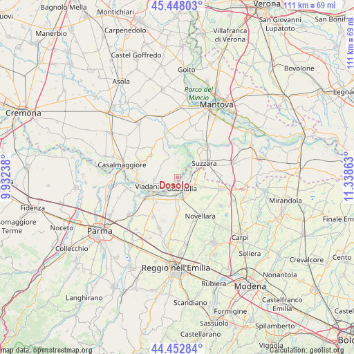
Dosolo GPS coordinates[2]
44° 57' 9.324" North, 10° 38' 7.8" East
| Map corner | latitude | longitude |
|---|---|---|
| Upper-left | 45.44803°, | 9.93238° |
| Center: | 44.95259°, | 10.6355° |
| Lower-right: | 44.45284°, | 11.33863° |
| Map W x H: | 110.7×110.7 km | = 68.8×68.8mi |
| max Lat: | 47.04031° ⇑41.1% North |
| Dosolo: | 44.95259° |
| min Lat: | ⇓58.9% South 35.50142° |
| min Long | Dosolo | max Long |
| 6.69888° | 10.6355° | 18.48682° |
| W 38.5%⇐ | ⇒61.5% E |
Elevation
Elevation of Dosolo is 22 m = 72 ft, and this is 284.7 m = 934 ft below average elevation for this country.
| Max E: |
2085 m = 6841 ft | 88.3% |
| Avg. | 306.7 m = 1006 ft | |
| Dosolo | 22 m = 72 ft | |
Min E: |
-4 m = -13 ft | 11.7% |
See also: Italy elevation on elevation.city.
Geographical zone
Dosolo is located in North temperate zone (between Tropic of Cancer and the Arctic Circle). Distance of this Northern Tropic circle is 2392.3 km =1486.5 mi to South.| Distance of | km | miles | from Dosolo |
|---|---|---|---|
| North Pole | 5008.8 | 3112.3 | to North |
| Arctic Circle | 2402.9 | 1493.1 | to North |
| Tropic Cancer | 2392.3 | 1486.5 | to South |
| Equator | 4998.3 | 3105.8 | to South |


Nearby cities:
15 places around Dosolo: (largest is in red/bold)
• Boretto
8.7 km =5.4 mi,  229°
229°
• Breda Cisoni
10.5 km =6.5 mi,  307°
307°
• Cizzolo
6.8 km =4.2 mi,  19°
19°
• Codisotto
8 km =5 mi,  65°
65°
• Gualtieri
6.2 km =3.9 mi,  185°
185°
• Guastalla
5 km =3.1 mi,  155°
155°
• Luzzara
4.3 km =2.7 mi,  80°
80°
• Pieve Saliceto
6.7 km =4.2 mi,  203°
203°
• Pomponesco
4 km =2.5 mi, 233°
• San Matteo
7.2 km =4.5 mi,  356°
356°
• Suzzara
9.6 km =6 mi,  62°
62°
• Tabellano
9.8 km =6.1 mi,  42°
42°
• Viadana
9.4 km =5.8 mi,  258°
258°
• Villarotta
9.1 km =5.7 mi,  109°
109°
• Villastrada
2.7 km =1.7 mi,  12°
12°
Sources, notices
• [Note1] Compared only with cities in Italy existing in our database
• [Src1] Map data: © OpenStreetMap contributors (CC-BY-SA)
• [Src2] Other city data from geonames.org with taken over terms of usage.
• [Src3] Geographical zone / Annual Mean Temperature by Robert A. Rohde @ Wikipedia
