Suzzara geodata
Suzzara (Lombardy) is a seat of a third-order administrative division; located in Italy in Europe/Rome (GMT+2) time zone. With population of 16,571 people, there are 545 cities with bigger population in this country. Compared to other cities in Italy, 59.7% of cities are located further ↓South; 60.4% of cities are located further →East and 89% of cities have higher elevation than Suzzara. Note1


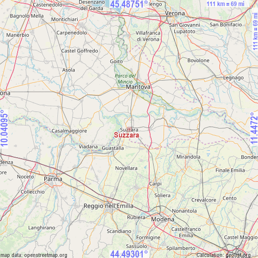
Suzzara GPS coordinates[2]
44° 59' 32.712" North, 10° 44' 38.652" East
| Map corner | latitude | longitude |
|---|---|---|
| Upper-left | 45.48751°, | 10.04095° |
| Center: | 44.99242°, | 10.74407° |
| Lower-right: | 44.49301°, | 11.4472° |
| Map W x H: | 110.6×110.6 km | = 68.7×68.7mi |
| max Lat: | 47.04031° ⇑40.3% North |
| Suzzara: | 44.99242° |
| min Lat: | ⇓59.7% South 35.50142° |
| min Long | Suzzara | max Long |
| 6.69888° | 10.74407° | 18.48682° |
| W 39.6%⇐ | ⇒60.4% E |
Elevation
Elevation of Suzzara is 20 m = 66 ft, and this is 286.7 m = 941 ft below average elevation for this country.
| Max E: |
2085 m = 6841 ft | 89% |
| Avg. | 306.7 m = 1006 ft | |
| Suzzara | 20 m = 66 ft | |
Min E: |
-4 m = -13 ft | 11% |
See also: Italy elevation on elevation.city.
Geographical zone
Suzzara is located in North temperate zone (between Tropic of Cancer and the Arctic Circle). Distance of this Northern Tropic circle is 2396.8 km =1489.3 mi to South.| Distance of | km | miles | from Suzzara |
|---|---|---|---|
| North Pole | 5004.4 | 3109.6 | to North |
| Arctic Circle | 2398.5 | 1490.4 | to North |
| Tropic Cancer | 2396.8 | 1489.3 | to South |
| Equator | 5002.7 | 3108.5 | to South |


Nearby cities:
15 places around Suzzara: (largest is in red/bold)
• Borgoforte
6.6 km =4.1 mi,  4°
4°
• Brugneto
8 km =5 mi,  169°
169°
• Cizzolo
6.5 km =4 mi,  287°
287°
• Codisotto
1.7 km =1.1 mi,  230°
230°
• Gonzaga
7.4 km =4.6 mi,  127°
127°
• Luzzara
5.7 km =3.5 mi, 229°
• Motteggiana
4.8 km =3 mi,  17°
17°
• Palidano
3.6 km =2.2 mi, 129°
• Pegognaga
9.1 km =5.7 mi,  88°
88°
• Polesine
4.8 km =3 mi,  98°
98°
• Romanore
8.4 km =5.2 mi,  6°
6°
• Tabellano
3.3 km =2.1 mi,  326°
326°
• Villa Saviola
6.1 km =3.8 mi,  46°
46°
• Villarotta
7.5 km =4.7 mi,  180°
180°
• Villastrada
8.2 km =5.1 mi,  257°
257°
Sources, notices
• [Note1] Compared only with cities in Italy existing in our database
• [Src1] Map data: © OpenStreetMap contributors (CC-BY-SA)
• [Src2] Other city data from geonames.org with taken over terms of usage.
• [Src3] Geographical zone / Annual Mean Temperature by Robert A. Rohde @ Wikipedia
