Lucignano geodata
Lucignano (Tuscany) is a seat of a third-order administrative division; located in Italy in Europe/Rome (GMT+2) time zone. With population of 1,748 people, there are 4576 cities with bigger population in this country. Compared to other cities in Italy, 61.3% of cities are located further ↑North; 52.4% of cities are located further ←West and 68.6% of cities have lower elevation than Lucignano. Note1


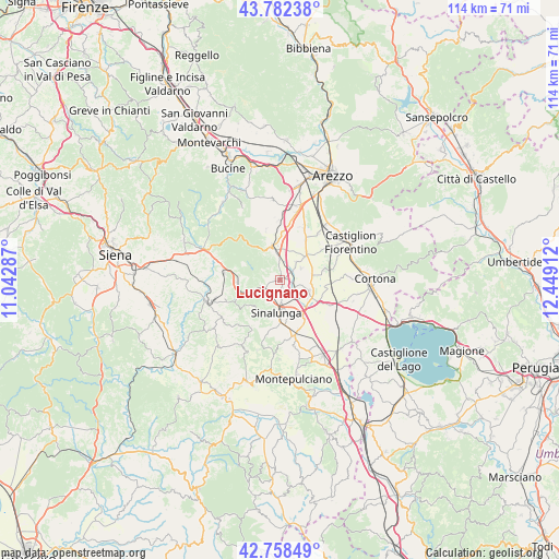
Lucignano GPS coordinates[2]
43° 16' 21.324" North, 11° 44' 45.564" East
| Map corner | latitude | longitude |
|---|---|---|
| Upper-left | 43.78238°, | 11.04287° |
| Center: | 43.27259°, | 11.74599° |
| Lower-right: | 42.75849°, | 12.44912° |
| Map W x H: | 113.8×113.8 km | = 70.7×70.7mi |
| max Lat: | 47.04031° ⇑61.3% North |
| Lucignano: | 43.27259° |
| min Lat: | ⇓38.7% South 35.50142° |
| min Long | Lucignano | max Long |
| 6.69888° | 11.74599° | 18.48682° |
| W 52.4%⇐ | ⇒47.6% E |
Elevation
Elevation of Lucignano is 380 m = 1247 ft, and this is 73.3 m = 240 ft above average elevation for this country.
| Max E: |
2085 m = 6841 ft | 31.4% |
| Lucignano | 380 m 1247 ft | |
| Avg. | 306.7 m = 1006 ft | |
Min E: |
-4 m = -13 ft | 68.6% |
See also: Italy elevation on elevation.city.
Geographical zone
Lucignano is located in North temperate zone (between Tropic of Cancer and the Arctic Circle). Distance of this Northern Tropic circle is 2205.5 km =1370.4 mi to South.| Distance of | km | miles | from Lucignano |
|---|---|---|---|
| North Pole | 5195.6 | 3228.4 | to North |
| Arctic Circle | 2589.7 | 1609.2 | to North |
| Tropic Cancer | 2205.5 | 1370.4 | to South |
| Equator | 4811.5 | 2989.7 | to South |


Nearby cities:
15 places around Lucignano: (largest is in red/bold)
• Alberoro
11.6 km =7.2 mi,  25°
25°
• Bettolle
8.7 km =5.4 mi,  147°
147°
• Cesa
7.3 km =4.5 mi,  48°
48°
• Ciggiano
10.6 km =6.6 mi,  345°
345°
• Foiano della Chiana
6.1 km =3.8 mi,  110°
110°
• Guazzino
7.3 km =4.5 mi,  156°
156°
• Marciano
5.3 km =3.3 mi,  44°
44°
• Marciano della Chiana
4.9 km =3 mi, 42°
• Montagnano
9.5 km =5.9 mi, 33°
• Monte San Savino
6.8 km =4.2 mi, 346°
• Pozzo della Chiana
4.9 km =3 mi,  62°
62°
• Serre di Rapolano
10.6 km =6.6 mi,  260°
260°
• Sinalunga
6.4 km =4 mi,  180°
180°
• Torrita di Siena
11.5 km =7.1 mi, 164°
• Trequanda
11.4 km =7.1 mi,  213°
213°
Sources, notices
• [Note1] Compared only with cities in Italy existing in our database
• [Src1] Map data: © OpenStreetMap contributors (CC-BY-SA)
• [Src2] Other city data from geonames.org with taken over terms of usage.
• [Src3] Geographical zone / Annual Mean Temperature by Robert A. Rohde @ Wikipedia
