Cenaia geodata
Cenaia (Tuscany) is a populated place; located in Italy in Europe/Rome (GMT+2) time zone. With population of 2,086 people, there are 4011 cities with bigger population in this country. Compared to other cities in Italy, 58.9% of cities are located further ↑North; 62.4% of cities are located further →East and 88.7% of cities have higher elevation than Cenaia. Note1


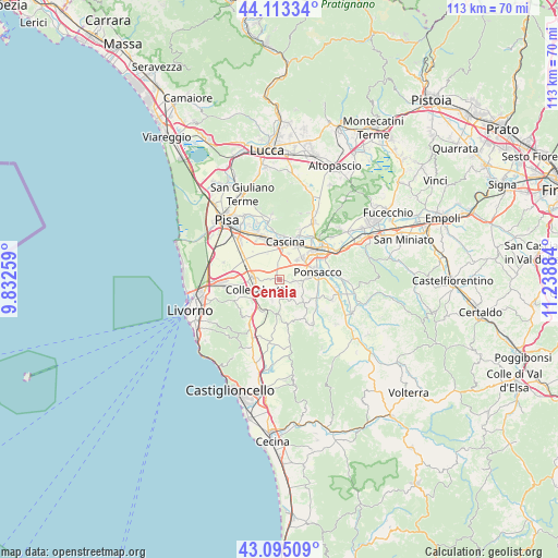
Cenaia GPS coordinates[2]
43° 36' 22.932" North, 10° 32' 8.556" East
| Map corner | latitude | longitude |
|---|---|---|
| Upper-left | 44.11334°, | 9.83259° |
| Center: | 43.60637°, | 10.53571° |
| Lower-right: | 43.09509°, | 11.23884° |
| Map W x H: | 113.2×113.2 km | = 70.3×70.3mi |
| max Lat: | 47.04031° ⇑58.9% North |
| Cenaia: | 43.60637° |
| min Lat: | ⇓41.1% South 35.50142° |
| min Long | Cenaia | max Long |
| 6.69888° | 10.53571° | 18.48682° |
| W 37.6%⇐ | ⇒62.4% E |
Elevation
Elevation of Cenaia is 21 m = 69 ft, and this is 285.7 m = 937 ft below average elevation for this country.
| Max E: |
2085 m = 6841 ft | 88.7% |
| Avg. | 306.7 m = 1006 ft | |
| Cenaia | 21 m = 69 ft | |
Min E: |
-4 m = -13 ft | 11.3% |
See also: Italy elevation on elevation.city.
Geographical zone
Cenaia is located in North temperate zone (between Tropic of Cancer and the Arctic Circle). Distance of this Northern Tropic circle is 2242.7 km =1393.5 mi to South.| Distance of | km | miles | from Cenaia |
|---|---|---|---|
| North Pole | 5158.5 | 3205.3 | to North |
| Arctic Circle | 2552.6 | 1586.1 | to North |
| Tropic Cancer | 2242.7 | 1393.5 | to South |
| Equator | 4848.6 | 3012.8 | to South |


Nearby cities:
15 places around Cenaia: (largest is in red/bold)
• Cascina
7.8 km =4.8 mi,  11°
11°
• Collesalvetti
5.2 km =3.2 mi,  250°
250°
• Crespina
4.4 km =2.7 mi,  148°
148°
• Fauglia
4.3 km =2.7 mi,  204°
204°
• Fornacette
8.1 km =5 mi,  29°
29°
• Lari
6.4 km =4 mi,  134°
134°
• Latignano
5.7 km =3.5 mi,  19°
19°
• Lavaiano
4.7 km =2.9 mi,  56°
56°
• Le Casine-Perignano-Spinelli
3.9 km =2.4 mi,  100°
100°
• Lorenzana
7.9 km =4.9 mi,  180°
180°
• Nugola
8.3 km =5.2 mi, 247°
• Ponsacco
7.5 km =4.7 mi,  75°
75°
• Quattro Strade
2.8 km =1.7 mi,  92°
92°
• Santa Lucia
7.4 km =4.6 mi, 55°
• Vicarello
5.7 km =3.5 mi,  276°
276°
Sources, notices
• [Note1] Compared only with cities in Italy existing in our database
• [Src1] Map data: © OpenStreetMap contributors (CC-BY-SA)
• [Src2] Other city data from geonames.org with taken over terms of usage.
• [Src3] Geographical zone / Annual Mean Temperature by Robert A. Rohde @ Wikipedia
