Lomagna geodata
Lomagna (Lombardy) is a seat of a third-order administrative division; located in Italy in Europe/Rome (GMT+2) time zone. With population of 4,497 people, there are 2147 cities with bigger population in this country. Compared to other cities in Italy, 79.7% of cities are located further ↓South; 75% of cities are located further →East and 53.8% of cities have lower elevation than Lomagna. Note1


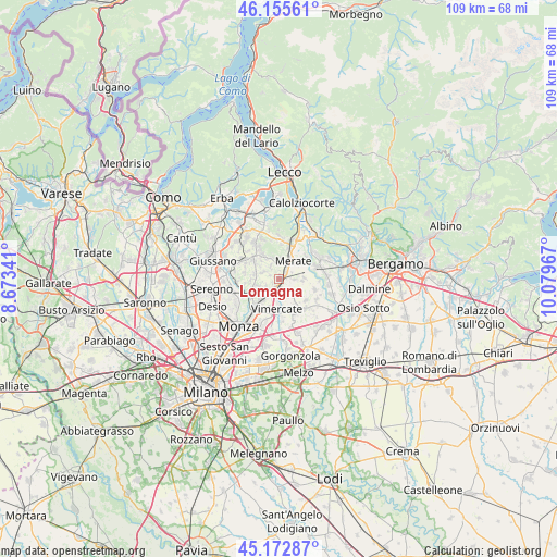
Lomagna GPS coordinates[2]
45° 39' 59.04" North, 9° 22' 35.544" East
| Map corner | latitude | longitude |
|---|---|---|
| Upper-left | 46.15561°, | 8.67341° |
| Center: | 45.6664°, | 9.37654° |
| Lower-right: | 45.17287°, | 10.07967° |
| Map W x H: | 109.3×109.3 km | = 67.9×67.9mi |
| max Lat: | 47.04031° ⇑20.3% North |
| Lomagna: | 45.6664° |
| min Lat: | ⇓79.7% South 35.50142° |
| min Long | Lomagna | max Long |
| 6.69888° | 9.37654° | 18.48682° |
| W 25%⇐ | ⇒75% E |
Elevation
Elevation of Lomagna is 258 m = 846 ft, and this is 48.7 m = 160 ft below average elevation for this country.
| Max E: |
2085 m = 6841 ft | 46.2% |
| Avg. | 306.7 m = 1006 ft | |
| Lomagna | 258 m = 846 ft | |
Min E: |
-4 m = -13 ft | 53.8% |
See also: Italy elevation on elevation.city.
Geographical zone
Lomagna is located in North temperate zone (between Tropic of Cancer and the Arctic Circle). Distance of this North polar circle is 2323.5 km =1443.8 mi to North.| Distance of | km | miles | from Lomagna |
|---|---|---|---|
| North Pole | 4929.4 | 3063 | to North |
| Arctic Circle | 2323.5 | 1443.8 | to North |
| Tropic Cancer | 2471.7 | 1535.8 | to South |
| Equator | 5077.6 | 3155.1 | to South |


Nearby cities:
15 places around Lomagna: (largest is in red/bold)
• Aicurzio
4.2 km =2.6 mi,  134°
134°
• Bernareggio
3 km =1.9 mi, 133°
• Camparada
4.3 km =2.7 mi,  252°
252°
• Carnate
2 km =1.2 mi,  176°
176°
• Cernusco Lombardone
3.2 km =2 mi,  32°
32°
• Maresso
2.8 km =1.7 mi,  325°
325°
• Merate
4.2 km =2.6 mi,  54°
54°
• Montevecchia
4.4 km =2.7 mi,  4°
4°
• Osnago
1.6 km =1 mi, 49°
• Quattro Strade
3.2 km =2 mi, 0°
• Rogoredo-Valaperta-Rimoldo
3.6 km =2.2 mi,  289°
289°
• Ronco Briantino
2.2 km =1.4 mi,  90°
90°
• Usmate-Velate
2.3 km =1.4 mi,  208°
208°
• Velasca
4.2 km =2.6 mi,  203°
203°
• Villanova
3.1 km =1.9 mi,  157°
157°
Sources, notices
• [Note1] Compared only with cities in Italy existing in our database
• [Src1] Map data: © OpenStreetMap contributors (CC-BY-SA)
• [Src2] Other city data from geonames.org with taken over terms of usage.
• [Src3] Geographical zone / Annual Mean Temperature by Robert A. Rohde @ Wikipedia
