Montevecchia geodata
Montevecchia (Lombardy) is a seat of a third-order administrative division; located in Italy in Europe/Rome (GMT+2) time zone. With population of 117 people, there are 11388 cities with bigger population in this country. Compared to other cities in Italy, 81.4% of cities are located further ↓South; 74.9% of cities are located further →East and 69.8% of cities have lower elevation than Montevecchia. Note1


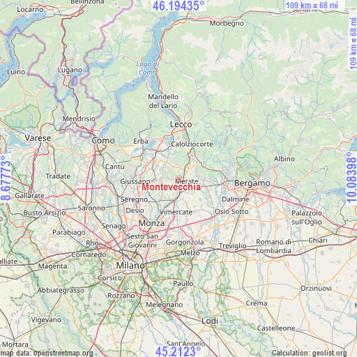
Montevecchia GPS coordinates[2]
45° 42' 19.728" North, 9° 22' 51.06" East
| Map corner | latitude | longitude |
|---|---|---|
| Upper-left | 46.19435°, | 8.67773° |
| Center: | 45.70548°, | 9.38085° |
| Lower-right: | 45.2123°, | 10.08398° |
| Map W x H: | 109.2×109.2 km | = 67.9×67.9mi |
| max Lat: | 47.04031° ⇑18.6% North |
| Montevecchia: | 45.70548° |
| min Lat: | ⇓81.4% South 35.50142° |
| min Long | Montevecchia | max Long |
| 6.69888° | 9.38085° | 18.48682° |
| W 25.1%⇐ | ⇒74.9% E |
Elevation
Elevation of Montevecchia is 392 m = 1286 ft, and this is 85.3 m = 280 ft above average elevation for this country.
| Max E: |
2085 m = 6841 ft | 30.2% |
| Montevecchia | 392 m 1286 ft | |
| Avg. | 306.7 m = 1006 ft | |
Min E: |
-4 m = -13 ft | 69.8% |
See also: Italy elevation on elevation.city.
Geographical zone
Montevecchia is located in North temperate zone (between Tropic of Cancer and the Arctic Circle). Distance of this North polar circle is 2319.2 km =1441.1 mi to North.| Distance of | km | miles | from Montevecchia |
|---|---|---|---|
| North Pole | 4925.1 | 3060.3 | to North |
| Arctic Circle | 2319.2 | 1441.1 | to North |
| Tropic Cancer | 2476.1 | 1538.6 | to South |
| Equator | 5082 | 3157.8 | to South |


Nearby cities:
15 places around Montevecchia: (largest is in red/bold)
• Calco
3.2 km =2 mi,  49°
49°
• Canova-San Zeno
2.3 km =1.4 mi,  40°
40°
• Cassina Fra Martino
4.3 km =2.7 mi,  71°
71°
• Cernusco Lombardone
2.2 km =1.4 mi,  138°
138°
• Lomaniga
1.8 km =1.1 mi,  262°
262°
• Maresso
2.8 km =1.7 mi,  224°
224°
• Merate
3.6 km =2.2 mi,  121°
121°
• Missaglia
3.6 km =2.2 mi,  271°
271°
• Monticello-Mondonico
3.5 km =2.2 mi,  16°
16°
• Olgiate Molgora
3.3 km =2.1 mi,  32°
32°
• Osnago
3.4 km =2.1 mi,  165°
165°
• Perego
3.8 km =2.4 mi,  338°
338°
• Quattro Strade
1.2 km =0.7 mi,  195°
195°
• Rovagnate
3.6 km =2.2 mi,  347°
347°
• Santa Maria Hoè
4.3 km =2.7 mi, 353°
Sources, notices
• [Note1] Compared only with cities in Italy existing in our database
• [Src1] Map data: © OpenStreetMap contributors (CC-BY-SA)
• [Src2] Other city data from geonames.org with taken over terms of usage.
• [Src3] Geographical zone / Annual Mean Temperature by Robert A. Rohde @ Wikipedia
