Castelbottaccio geodata
Castelbottaccio (Molise) is a seat of a third-order administrative division; located in Italy in Europe/Rome (GMT+2) time zone. With population of 349 people, there are 10483 cities with bigger population in this country. Compared to other cities in Italy, 72.4% of cities are located further ↑North; 84.5% of cities are located further ←West and 85.5% of cities have lower elevation than Castelbottaccio. Note1
Administrative division(s):
- Level 1: Molise
- Level 2: Provincia di Campobasso
- Level 3: Castelbottaccio


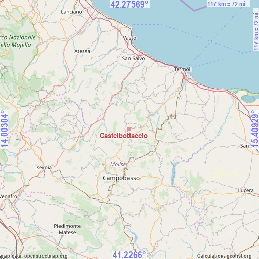
Castelbottaccio GPS coordinates[2]
41° 45' 11.844" North, 14° 42' 22.176" East
| Map corner | latitude | longitude |
|---|---|---|
| Upper-left | 42.27569°, | 14.00304° |
| Center: | 41.75329°, | 14.70616° |
| Lower-right: | 41.2266°, | 15.40929° |
| Map W x H: | 116.6×116.6 km | = 72.5×72.5mi |
| max Lat: | 47.04031° ⇑72.4% North |
| Castelbottaccio: | 41.75329° |
| min Lat: | ⇓27.6% South 35.50142° |
| min Long | Castelbottaccio | max Long |
| 6.69888° | 14.70616° | 18.48682° |
| W 84.5%⇐ | ⇒15.5% E |
Elevation
Elevation of Castelbottaccio is 622 m = 2041 ft, and this is 315.3 m = 1034 ft above average elevation for this country.
| Max E: |
2085 m = 6841 ft | 14.5% |
| Castelbottaccio | 622 m 2041 ft | |
| Avg. | 306.7 m = 1006 ft | |
Min E: |
-4 m = -13 ft | 85.5% |
See also: Italy elevation on elevation.city.
Geographical zone
Castelbottaccio is located in North temperate zone (between Tropic of Cancer and the Arctic Circle). Distance of this Northern Tropic circle is 2036.6 km =1265.5 mi to South.| Distance of | km | miles | from Castelbottaccio |
|---|---|---|---|
| North Pole | 5364.5 | 3333.3 | to North |
| Arctic Circle | 2758.6 | 1714.1 | to North |
| Tropic Cancer | 2036.6 | 1265.5 | to South |
| Equator | 4642.5 | 2884.7 | to South |


Nearby cities:
15 places around Castelbottaccio: (largest is in red/bold)
• Casacalenda
11.8 km =7.3 mi,  98°
98°
• Castellino del Biferno
6.1 km =3.8 mi,  159°
159°
• Castelmauro
8.4 km =5.2 mi,  2°
2°
• Civitacampomarano
3.3 km =2.1 mi,  334°
334°
• Guardialfiera
9.2 km =5.7 mi,  51°
51°
• Limosano
11.1 km =6.9 mi,  218°
218°
• Lucito
2.8 km =1.7 mi,  213°
213°
• Lupara
2.5 km =1.6 mi,  68°
68°
• Montagano
12.3 km =7.6 mi,  192°
192°
• Morrone del Sannio
7.8 km =4.8 mi,  127°
127°
• Petrella Tifernina
6.9 km =4.3 mi, 185°
• Provvidenti
10.5 km =6.5 mi,  111°
111°
• Ripabottoni
11 km =6.8 mi, 129°
• San Biase
10.5 km =6.5 mi,  246°
246°
• Sant'Angelo Limosano
10.9 km =6.8 mi,  231°
231°
Sources, notices
• [Note1] Compared only with cities in Italy existing in our database
• [Src1] Map data: © OpenStreetMap contributors (CC-BY-SA)
• [Src2] Other city data from geonames.org with taken over terms of usage.
• [Src3] Geographical zone / Annual Mean Temperature by Robert A. Rohde @ Wikipedia
