Bolognano geodata
Bolognano (Abruzzo) is a seat of a third-order administrative division; located in Italy in Europe/Rome (GMT+2) time zone. With population of 227 people, there are 10998 cities with bigger population in this country. Compared to other cities in Italy, 68.6% of cities are located further ↑North; 77.9% of cities are located further ←West and 59.6% of cities have lower elevation than Bolognano. Note1


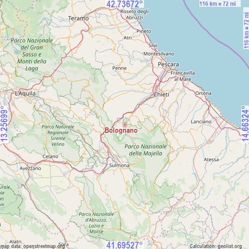
Bolognano GPS coordinates[2]
42° 13' 5.304" North, 13° 57' 36.396" East
| Map corner | latitude | longitude |
|---|---|---|
| Upper-left | 42.73672°, | 13.25699° |
| Center: | 42.21814°, | 13.96011° |
| Lower-right: | 41.69527°, | 14.66324° |
| Map W x H: | 115.8×115.8 km | = 72×72mi |
| max Lat: | 47.04031° ⇑68.6% North |
| Bolognano: | 42.21814° |
| min Lat: | ⇓31.4% South 35.50142° |
| min Long | Bolognano | max Long |
| 6.69888° | 13.96011° | 18.48682° |
| W 77.9%⇐ | ⇒22.1% E |
Elevation
Elevation of Bolognano is 297 m = 974 ft, and this is 9.7 m = 32 ft below average elevation for this country.
| Max E: |
2085 m = 6841 ft | 40.4% |
| Avg. | 306.7 m = 1006 ft | |
| Bolognano | 297 m = 974 ft | |
Min E: |
-4 m = -13 ft | 59.6% |
See also: Italy elevation on elevation.city.
Geographical zone
Bolognano is located in North temperate zone (between Tropic of Cancer and the Arctic Circle). Distance of this Northern Tropic circle is 2088.3 km =1297.6 mi to South.| Distance of | km | miles | from Bolognano |
|---|---|---|---|
| North Pole | 5312.8 | 3301.2 | to North |
| Arctic Circle | 2707 | 1682.1 | to North |
| Tropic Cancer | 2088.3 | 1297.6 | to South |
| Equator | 4694.2 | 2916.8 | to South |


Nearby cities:
15 places around Bolognano: (largest is in red/bold)
• Abbateggio
4.2 km =2.6 mi,  80°
80°
• Alanno
8.6 km =5.3 mi,  5°
5°
• Caramanico Terme
7.8 km =4.8 mi,  151°
151°
• Castiglione a Casauria
5.5 km =3.4 mi,  291°
291°
• Lettomanoppello
7 km =4.3 mi,  66°
66°
• Pescosansonesco Nuovo
7.4 km =4.6 mi,  303°
303°
• Pietranico
7.6 km =4.7 mi,  327°
327°
• Roccamorice
5.4 km =3.4 mi,  96°
96°
• Salle
4.5 km =2.8 mi,  179°
179°
• San Valentino in Abruzzo Citeriore
2.7 km =1.7 mi,  51°
51°
• Scafa
6.1 km =3.8 mi,  29°
29°
• Ticchione
9.2 km =5.7 mi, 27°
• Tocco da Casauria
3.7 km =2.3 mi,  259°
259°
• Torre de' Passeri
3.6 km =2.2 mi,  321°
321°
• Turrivalignani
7.5 km =4.7 mi, 48°
Sources, notices
• [Note1] Compared only with cities in Italy existing in our database
• [Src1] Map data: © OpenStreetMap contributors (CC-BY-SA)
• [Src2] Other city data from geonames.org with taken over terms of usage.
• [Src3] Geographical zone / Annual Mean Temperature by Robert A. Rohde @ Wikipedia
