Lestizza geodata
Lestizza (Friuli Venezia Giulia) is a seat of a third-order administrative division; located in Italy in Europe/Rome (GMT+2) time zone. With population of 882 people, there are 7255 cities with bigger population in this country. Compared to other cities in Italy, 90.8% of cities are located further ↓South; 69.8% of cities are located further ←West and 82% of cities have higher elevation than Lestizza. Note1
Administrative division(s):
- Level 1: Friuli Venezia Giulia
- Level 2: Provincia di Udine
- Level 3: Lestizza


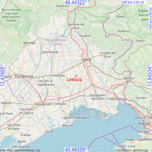
Lestizza GPS coordinates[2]
45° 57' 23.616" North, 13° 8' 31.956" East
| Map corner | latitude | longitude |
|---|---|---|
| Upper-left | 46.44322°, | 12.43909° |
| Center: | 45.95656°, | 13.14221° |
| Lower-right: | 45.46559°, | 13.84534° |
| Map W x H: | 108.7×108.7 km | = 67.5×67.5mi |
| max Lat: | 47.04031° ⇑9.2% North |
| Lestizza: | 45.95656° |
| min Lat: | ⇓90.8% South 35.50142° |
| min Long | Lestizza | max Long |
| 6.69888° | 13.14221° | 18.48682° |
| W 69.8%⇐ | ⇒30.2% E |
Elevation
Elevation of Lestizza is 42 m = 138 ft, and this is 264.7 m = 868 ft below average elevation for this country.
| Max E: |
2085 m = 6841 ft | 82% |
| Avg. | 306.7 m = 1006 ft | |
| Lestizza | 42 m = 138 ft | |
Min E: |
-4 m = -13 ft | 18% |
See also: Italy elevation on elevation.city.
Geographical zone
Lestizza is located in North temperate zone (between Tropic of Cancer and the Arctic Circle). Distance of this North polar circle is 2291.3 km =1423.7 mi to North.| Distance of | km | miles | from Lestizza |
|---|---|---|---|
| North Pole | 4897.2 | 3043 | to North |
| Arctic Circle | 2291.3 | 1423.7 | to North |
| Tropic Cancer | 2504 | 1555.9 | to South |
| Equator | 5109.9 | 3175.1 | to South |


Nearby cities:
15 places around Lestizza: (largest is in red/bold)
• Bertiolo
6.8 km =4.2 mi,  258°
258°
• Campoformido
7.1 km =4.4 mi,  9°
9°
• Carpeneto
5.2 km =3.2 mi,  31°
31°
• Castions di Strada
5.8 km =3.6 mi,  148°
148°
• Galleriano
1.6 km =1 mi,  296°
296°
• Lavariano
6.7 km =4.2 mi,  90°
90°
• Mortegliano
2.6 km =1.6 mi,  117°
117°
• Nespoledo-Villacaccia
4.9 km =3 mi,  306°
306°
• Pozzecco
4 km =2.5 mi,  272°
272°
• Pozzuolo del Friuli
5.3 km =3.3 mi,  53°
53°
• Sammardenchia
7.5 km =4.7 mi,  64°
64°
• Santa Maria
2 km =1.2 mi,  43°
43°
• Sclaunicco
2.2 km =1.4 mi,  349°
349°
• Talmassons
3.5 km =2.2 mi,  206°
206°
• Zugliano-Terenzano-Cargnacco
8.1 km =5 mi, 45°
Sources, notices
• [Note1] Compared only with cities in Italy existing in our database
• [Src1] Map data: © OpenStreetMap contributors (CC-BY-SA)
• [Src2] Other city data from geonames.org with taken over terms of usage.
• [Src3] Geographical zone / Annual Mean Temperature by Robert A. Rohde @ Wikipedia
