Pozzecco geodata
Pozzecco (Friuli Venezia Giulia) is a populated place; located in Italy in Europe/Rome (GMT+2) time zone. With population of 526 people, there are 9676 cities with bigger population in this country. Compared to other cities in Italy, 90.9% of cities are located further ↓South; 69.3% of cities are located further ←West and 82.2% of cities have higher elevation than Pozzecco. Note1
Administrative division(s):
- Level 1: Friuli Venezia Giulia
- Level 2: Provincia di Udine
- Level 3: Bertiolo


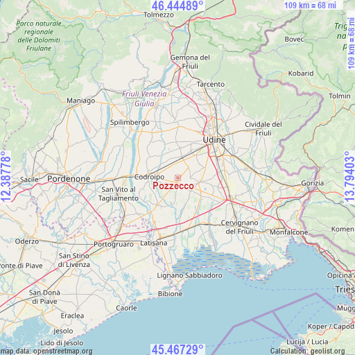
Pozzecco GPS coordinates[2]
45° 57' 29.7" North, 13° 5' 27.24" East
| Map corner | latitude | longitude |
|---|---|---|
| Upper-left | 46.44489°, | 12.38778° |
| Center: | 45.95825°, | 13.0909° |
| Lower-right: | 45.46729°, | 13.79403° |
| Map W x H: | 108.7×108.7 km | = 67.5×67.5mi |
| max Lat: | 47.04031° ⇑9.1% North |
| Pozzecco: | 45.95825° |
| min Lat: | ⇓90.9% South 35.50142° |
| min Long | Pozzecco | max Long |
| 6.69888° | 13.0909° | 18.48682° |
| W 69.3%⇐ | ⇒30.7% E |
Elevation
Elevation of Pozzecco is 41 m = 135 ft, and this is 265.7 m = 872 ft below average elevation for this country.
| Max E: |
2085 m = 6841 ft | 82.2% |
| Avg. | 306.7 m = 1006 ft | |
| Pozzecco | 41 m = 135 ft | |
Min E: |
-4 m = -13 ft | 17.8% |
See also: Italy elevation on elevation.city.
Geographical zone
Pozzecco is located in North temperate zone (between Tropic of Cancer and the Arctic Circle). Distance of this North polar circle is 2291.1 km =1423.6 mi to North.| Distance of | km | miles | from Pozzecco |
|---|---|---|---|
| North Pole | 4897 | 3042.9 | to North |
| Arctic Circle | 2291.1 | 1423.6 | to North |
| Tropic Cancer | 2504.2 | 1556 | to South |
| Equator | 5110.1 | 3175.3 | to South |


Nearby cities:
15 places around Pozzecco: (largest is in red/bold)
• Basiliano
6.4 km =4 mi,  345°
345°
• Basiliano-Vissandone
7.2 km =4.5 mi,  1°
1°
• Bertiolo
3.1 km =1.9 mi,  240°
240°
• Carpeneto
7.9 km =4.9 mi,  57°
57°
• Galleriano
2.6 km =1.6 mi,  78°
78°
• Lestizza
4 km =2.5 mi,  92°
92°
• Mortegliano
6.5 km =4 mi,  102°
102°
• Nespoledo-Villacaccia
2.8 km =1.7 mi,  359°
359°
• Pantianicco
8.4 km =5.2 mi,  329°
329°
• Rivolto-Lonca
5.4 km =3.4 mi,  255°
255°
• Santa Maria
5.5 km =3.4 mi, 76°
• Sclaunicco
4.1 km =2.5 mi, 60°
• Talmassons
4.1 km =2.5 mi,  144°
144°
• Variano
7.8 km =4.8 mi,  12°
12°
• Villaorba
6 km =3.7 mi,  344°
344°
Sources, notices
• [Note1] Compared only with cities in Italy existing in our database
• [Src1] Map data: © OpenStreetMap contributors (CC-BY-SA)
• [Src2] Other city data from geonames.org with taken over terms of usage.
• [Src3] Geographical zone / Annual Mean Temperature by Robert A. Rohde @ Wikipedia
