Bertiolo geodata
Bertiolo (Friuli Venezia Giulia) is a seat of a third-order administrative division; located in Italy in Europe/Rome (GMT+2) time zone. With population of 1,996 people, there are 4163 cities with bigger population in this country. Compared to other cities in Italy, 90.4% of cities are located further ↓South; 68.9% of cities are located further ←West and 84.4% of cities have higher elevation than Bertiolo. Note1
Administrative division(s):
- Level 1: Friuli Venezia Giulia
- Level 2: Provincia di Udine
- Level 3: Bertiolo


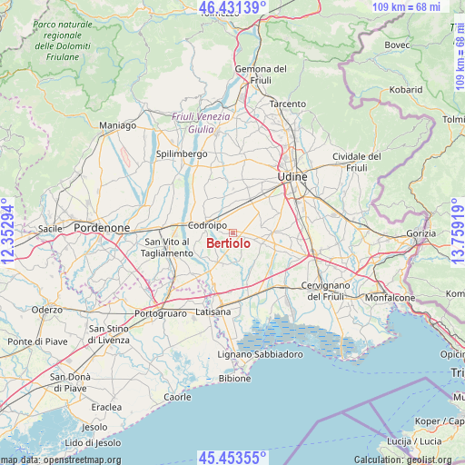
Bertiolo GPS coordinates[2]
45° 56' 40.668" North, 13° 3' 21.816" East
| Map corner | latitude | longitude |
|---|---|---|
| Upper-left | 46.43139°, | 12.35294° |
| Center: | 45.94463°, | 13.05606° |
| Lower-right: | 45.45355°, | 13.75919° |
| Map W x H: | 108.7×108.7 km | = 67.5×67.5mi |
| max Lat: | 47.04031° ⇑9.6% North |
| Bertiolo: | 45.94463° |
| min Lat: | ⇓90.4% South 35.50142° |
| min Long | Bertiolo | max Long |
| 6.69888° | 13.05606° | 18.48682° |
| W 68.9%⇐ | ⇒31.1% E |
Elevation
Elevation of Bertiolo is 33 m = 108 ft, and this is 273.7 m = 898 ft below average elevation for this country.
| Max E: |
2085 m = 6841 ft | 84.4% |
| Avg. | 306.7 m = 1006 ft | |
| Bertiolo | 33 m = 108 ft | |
Min E: |
-4 m = -13 ft | 15.6% |
See also: Italy elevation on elevation.city.
Geographical zone
Bertiolo is located in North temperate zone (between Tropic of Cancer and the Arctic Circle). Distance of this North polar circle is 2292.6 km =1424.6 mi to North.| Distance of | km | miles | from Bertiolo |
|---|---|---|---|
| North Pole | 4898.5 | 3043.8 | to North |
| Arctic Circle | 2292.6 | 1424.6 | to North |
| Tropic Cancer | 2502.6 | 1555 | to South |
| Equator | 5108.6 | 3174.3 | to South |


Nearby cities:
15 places around Bertiolo: (largest is in red/bold)
• Basiliano
7.8 km =4.8 mi,  7°
7°
• Codroipo
6.3 km =3.9 mi,  290°
290°
• Galleriano
5.6 km =3.5 mi,  69°
69°
• Lestizza
6.8 km =4.2 mi,  78°
78°
• Nespoledo-Villacaccia
5 km =3.1 mi,  32°
32°
• Pozzecco
3.1 km =1.9 mi,  60°
60°
• Rivignano
7.7 km =4.8 mi,  188°
188°
• Rivolto-Lonca
2.5 km =1.6 mi,  273°
273°
• Romans
5.8 km =3.6 mi,  209°
209°
• San Lorenzo
7.6 km =4.7 mi,  323°
323°
• Santa Maria
8.5 km =5.3 mi, 70°
• Sclaunicco
7.2 km =4.5 mi, 60°
• Talmassons
5.4 km =3.4 mi,  109°
109°
• Varmo
8.3 km =5.2 mi,  218°
218°
• Villaorba
7.4 km =4.6 mi, 8°
Sources, notices
• [Note1] Compared only with cities in Italy existing in our database
• [Src1] Map data: © OpenStreetMap contributors (CC-BY-SA)
• [Src2] Other city data from geonames.org with taken over terms of usage.
• [Src3] Geographical zone / Annual Mean Temperature by Robert A. Rohde @ Wikipedia
