Legnano geodata
Legnano (Lombardy) is a seat of a third-order administrative division; located in Italy in Europe/Rome (GMT+2) time zone. With population of 57,589 people, there are 94 cities with bigger population in this country. Compared to other cities in Italy, 77% of cities are located further ↓South; 82.5% of cities are located further →East and 54.4% of cities have higher elevation than Legnano. Note1
Administrative division(s):
- Level 1: Lombardy
- Level 2: Città metropolitana di Milano
- Level 3: Legnano


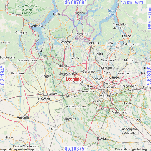
Legnano GPS coordinates[2]
45° 35' 52.368" North, 8° 54' 54.216" East
| Map corner | latitude | longitude |
|---|---|---|
| Upper-left | 46.08769°, | 8.21194° |
| Center: | 45.59788°, | 8.91506° |
| Lower-right: | 45.10375°, | 9.61819° |
| Map W x H: | 109.4×109.4 km | = 68×68mi |
| max Lat: | 47.04031° ⇑23% North |
| Legnano: | 45.59788° |
| min Lat: | ⇓77% South 35.50142° |
| min Long | Legnano | max Long |
| 6.69888° | 8.91506° | 18.48682° |
| W 17.5%⇐ | ⇒82.5% E |
Elevation
Elevation of Legnano is 206 m = 676 ft, and this is 100.7 m = 330 ft below average elevation for this country.
| Max E: |
2085 m = 6841 ft | 54.4% |
| Avg. | 306.7 m = 1006 ft | |
| Legnano | 206 m = 676 ft | |
Min E: |
-4 m = -13 ft | 45.6% |
See also: Legnano elevation on elevation.city.
Geographical zone
Legnano is located in North temperate zone (between Tropic of Cancer and the Arctic Circle). Distance of this North polar circle is 2331.2 km =1448.5 mi to North.| Distance of | km | miles | from Legnano |
|---|---|---|---|
| North Pole | 4937.1 | 3067.8 | to North |
| Arctic Circle | 2331.2 | 1448.5 | to North |
| Tropic Cancer | 2464.1 | 1531.1 | to South |
| Equator | 5070 | 3150.4 | to South |


Nearby cities:
15 places around Legnano: (largest is in red/bold)
• Busto Arsizio
5.3 km =3.3 mi,  286°
286°
• Busto Garolfo
6.1 km =3.8 mi,  204°
204°
• Canegrate
3.4 km =2.1 mi,  164°
164°
• Cantalupo
5.7 km =3.5 mi,  112°
112°
• Castellanza
2.1 km =1.3 mi,  314°
314°
• Cerro Maggiore
3.1 km =1.9 mi,  98°
98°
• Dairago
5.4 km =3.4 mi,  228°
228°
• Gorla Minore
4.9 km =3 mi,  348°
348°
• Marnate
3.4 km =2.1 mi, 352°
• Olgiate Olona
5.1 km =3.2 mi,  329°
329°
• Parabiago
4.8 km =3 mi,  150°
150°
• Rescaldina
3.6 km =2.2 mi,  46°
46°
• San Giorgio Su Legnano
2.7 km =1.7 mi,  182°
182°
• San Vittore Olona
2.4 km =1.5 mi,  123°
123°
• Villa Cortese
4.1 km =2.5 mi,  212°
212°
Sources, notices
• [Note1] Compared only with cities in Italy existing in our database
• [Src1] Map data: © OpenStreetMap contributors (CC-BY-SA)
• [Src2] Other city data from geonames.org with taken over terms of usage.
• [Src3] Geographical zone / Annual Mean Temperature by Robert A. Rohde @ Wikipedia
