Rescaldina geodata
Rescaldina (Lombardy) is a seat of a third-order administrative division; located in Italy in Europe/Rome (GMT+2) time zone. With population of 13,911 people, there are 651 cities with bigger population in this country. Compared to other cities in Italy, 77.9% of cities are located further ↓South; 81.9% of cities are located further →East and 51.3% of cities have higher elevation than Rescaldina. Note1
Administrative division(s):
- Level 1: Lombardy
- Level 2: Città metropolitana di Milano
- Level 3: Rescaldina


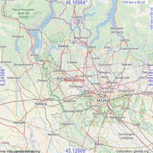
Rescaldina GPS coordinates[2]
45° 37' 12.072" North, 8° 56' 55.608" East
| Map corner | latitude | longitude |
|---|---|---|
| Upper-left | 46.10964°, | 8.24566° |
| Center: | 45.62002°, | 8.94878° |
| Lower-right: | 45.12609°, | 9.65191° |
| Map W x H: | 109.4×109.4 km | = 68×68mi |
| max Lat: | 47.04031° ⇑22.1% North |
| Rescaldina: | 45.62002° |
| min Lat: | ⇓77.9% South 35.50142° |
| min Long | Rescaldina | max Long |
| 6.69888° | 8.94878° | 18.48682° |
| W 18.1%⇐ | ⇒81.9% E |
Elevation
Elevation of Rescaldina is 226 m = 741 ft, and this is 80.7 m = 265 ft below average elevation for this country.
| Max E: |
2085 m = 6841 ft | 51.3% |
| Avg. | 306.7 m = 1006 ft | |
| Rescaldina | 226 m = 741 ft | |
Min E: |
-4 m = -13 ft | 48.7% |
See also: Italy elevation on elevation.city.
Geographical zone
Rescaldina is located in North temperate zone (between Tropic of Cancer and the Arctic Circle). Distance of this North polar circle is 2328.7 km =1447 mi to North.| Distance of | km | miles | from Rescaldina |
|---|---|---|---|
| North Pole | 4934.6 | 3066.2 | to North |
| Arctic Circle | 2328.7 | 1447 | to North |
| Tropic Cancer | 2466.6 | 1532.7 | to South |
| Equator | 5072.5 | 3151.9 | to South |


Nearby cities:
15 places around Rescaldina: (largest is in red/bold)
• Cantalupo
5.3 km =3.3 mi,  150°
150°
• Castellanza
4.2 km =2.6 mi,  255°
255°
• Cerro Maggiore
3 km =1.9 mi,  171°
171°
• Cislago
4.7 km =2.9 mi,  23°
23°
• Gerenzano
4.6 km =2.9 mi,  61°
61°
• Gorla Minore
4.3 km =2.7 mi,  303°
303°
• Legnano
3.6 km =2.2 mi,  226°
226°
• Marnate
3.2 km =2 mi,  287°
287°
• Massina
3.4 km =2.1 mi,  35°
35°
• Olgiate Olona
5.6 km =3.5 mi, 289°
• Origgio
5.9 km =3.7 mi,  116°
116°
• San Giorgio Su Legnano
5.8 km =3.6 mi,  207°
207°
• San Vittore Olona
3.9 km =2.4 mi,  188°
188°
• Turate
6 km =3.7 mi,  46°
46°
• Uboldo
4.3 km =2.7 mi,  97°
97°
Sources, notices
• [Note1] Compared only with cities in Italy existing in our database
• [Src1] Map data: © OpenStreetMap contributors (CC-BY-SA)
• [Src2] Other city data from geonames.org with taken over terms of usage.
• [Src3] Geographical zone / Annual Mean Temperature by Robert A. Rohde @ Wikipedia
