Castellanza geodata
Castellanza (Lombardy) is a seat of a third-order administrative division; located in Italy in Europe/Rome (GMT+2) time zone. With population of 14,223 people, there are 635 cities with bigger population in this country. Compared to other cities in Italy, 77.5% of cities are located further ↓South; 82.8% of cities are located further →East and 52% of cities have higher elevation than Castellanza. Note1


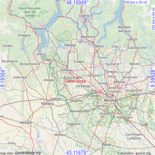
Castellanza GPS coordinates[2]
45° 36' 38.844" North, 8° 53' 46.176" East
| Map corner | latitude | longitude |
|---|---|---|
| Upper-left | 46.10049°, | 8.19304° |
| Center: | 45.61079°, | 8.89616° |
| Lower-right: | 45.11678°, | 9.59929° |
| Map W x H: | 109.4×109.4 km | = 68×68mi |
| max Lat: | 47.04031° ⇑22.5% North |
| Castellanza: | 45.61079° |
| min Lat: | ⇓77.5% South 35.50142° |
| min Long | Castellanza | max Long |
| 6.69888° | 8.89616° | 18.48682° |
| W 17.2%⇐ | ⇒82.8% E |
Elevation
Elevation of Castellanza is 222 m = 728 ft, and this is 84.7 m = 278 ft below average elevation for this country.
| Max E: |
2085 m = 6841 ft | 52% |
| Avg. | 306.7 m = 1006 ft | |
| Castellanza | 222 m = 728 ft | |
Min E: |
-4 m = -13 ft | 48% |
See also: Italy elevation on elevation.city.
Geographical zone
Castellanza is located in North temperate zone (between Tropic of Cancer and the Arctic Circle). Distance of this North polar circle is 2329.7 km =1447.6 mi to North.| Distance of | km | miles | from Castellanza |
|---|---|---|---|
| North Pole | 4935.6 | 3066.8 | to North |
| Arctic Circle | 2329.7 | 1447.6 | to North |
| Tropic Cancer | 2465.5 | 1532 | to South |
| Equator | 5071.4 | 3151.2 | to South |


Nearby cities:
15 places around Castellanza: (largest is in red/bold)
• Busto Arsizio
3.7 km =2.3 mi,  270°
270°
• Canegrate
5.3 km =3.3 mi,  153°
153°
• Cerro Maggiore
4.9 km =3 mi,  112°
112°
• Dairago
5.6 km =3.5 mi,  207°
207°
• Gorla Maggiore
5.9 km =3.7 mi,  359°
359°
• Gorla Minore
3.4 km =2.1 mi,  8°
8°
• Legnano
2.1 km =1.3 mi,  134°
134°
• Marnate
2.2 km =1.4 mi,  27°
27°
• Olgiate Olona
3.1 km =1.9 mi,  338°
338°
• Parabiago
6.8 km =4.2 mi, 145°
• Rescaldina
4.2 km =2.6 mi,  75°
75°
• San Giorgio Su Legnano
4.3 km =2.7 mi,  161°
161°
• San Vittore Olona
4.5 km =2.8 mi, 128°
• Solbiate Olona
4.5 km =2.8 mi,  345°
345°
• Villa Cortese
5 km =3.1 mi,  188°
188°
Sources, notices
• [Note1] Compared only with cities in Italy existing in our database
• [Src1] Map data: © OpenStreetMap contributors (CC-BY-SA)
• [Src2] Other city data from geonames.org with taken over terms of usage.
• [Src3] Geographical zone / Annual Mean Temperature by Robert A. Rohde @ Wikipedia
