Legnago geodata
Legnago (Veneto) is a seat of a third-order administrative division; located in Italy in Europe/Rome (GMT+2) time zone. With population of 21,646 people, there are 410 cities with bigger population in this country. Compared to other cities in Italy, 64.8% of cities are located further ↓South; 53.1% of cities are located further →East and 91.5% of cities have higher elevation than Legnago. Note1


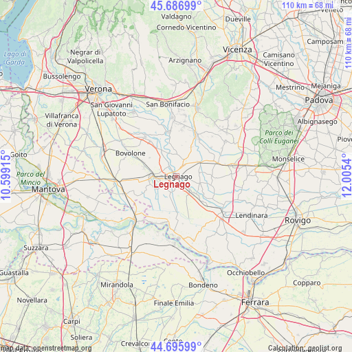
Legnago GPS coordinates[2]
45° 11' 37.14" North, 11° 18' 8.172" East
| Map corner | latitude | longitude |
|---|---|---|
| Upper-left | 45.68699°, | 10.59915° |
| Center: | 45.19365°, | 11.30227° |
| Lower-right: | 44.69599°, | 12.0054° |
| Map W x H: | 110.2×110.2 km | = 68.5×68.5mi |
| max Lat: | 47.04031° ⇑35.2% North |
| Legnago: | 45.19365° |
| min Lat: | ⇓64.8% South 35.50142° |
| min Long | Legnago | max Long |
| 6.69888° | 11.30227° | 18.48682° |
| W 46.9%⇐ | ⇒53.1% E |
Elevation
Elevation of Legnago is 15 m = 49 ft, and this is 291.7 m = 957 ft below average elevation for this country.
| Max E: |
2085 m = 6841 ft | 91.5% |
| Avg. | 306.7 m = 1006 ft | |
| Legnago | 15 m = 49 ft | |
Min E: |
-4 m = -13 ft | 8.5% |
See also: Italy elevation on elevation.city.
Geographical zone
Legnago is located in North temperate zone (between Tropic of Cancer and the Arctic Circle). Distance of this North polar circle is 2376.1 km =1476.4 mi to North.| Distance of | km | miles | from Legnago |
|---|---|---|---|
| North Pole | 4982 | 3095.7 | to North |
| Arctic Circle | 2376.1 | 1476.4 | to North |
| Tropic Cancer | 2419.1 | 1503.2 | to South |
| Equator | 5025.1 | 3122.5 | to South |


Nearby cities:
15 places around Legnago: (largest is in red/bold)
• Angiari
3.8 km =2.4 mi,  328°
328°
• Bevilacqua
8.4 km =5.2 mi,  59°
59°
• Bonavigo
7.4 km =4.6 mi,  346°
346°
• Boschi Sant'Anna
5 km =3.1 mi, 57°
• Casaleone
8.9 km =5.5 mi,  251°
251°
• Cerea
6.7 km =4.2 mi,  265°
265°
• Coriano
9.2 km =5.7 mi, 353°
• Gallese
4.1 km =2.5 mi,  33°
33°
• Minerbe
5.8 km =3.6 mi,  42°
42°
• Roverchiara
9.4 km =5.8 mi, 331°
• Roverchiaretta
7.9 km =4.9 mi,  335°
335°
• San Pietro di Morubio
8 km =5 mi,  312°
312°
• Spinimbecco
7.8 km =4.8 mi,  135°
135°
• Terrazzo
7.6 km =4.7 mi,  107°
107°
• Villa Bartolomea
5.9 km =3.7 mi, 137°
Sources, notices
• [Note1] Compared only with cities in Italy existing in our database
• [Src1] Map data: © OpenStreetMap contributors (CC-BY-SA)
• [Src2] Other city data from geonames.org with taken over terms of usage.
• [Src3] Geographical zone / Annual Mean Temperature by Robert A. Rohde @ Wikipedia
