Landriano geodata
Landriano (Lombardy) is a seat of a third-order administrative division; located in Italy in Europe/Rome (GMT+2) time zone. With population of 4,998 people, there are 1957 cities with bigger population in this country. Compared to other cities in Italy, 67.7% of cities are located further ↓South; 77.1% of cities are located further →East and 72% of cities have higher elevation than Landriano. Note1


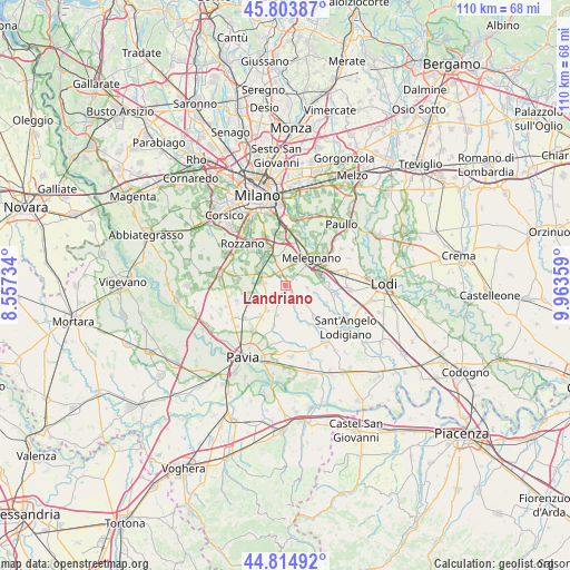
Landriano GPS coordinates[2]
45° 18' 41.58" North, 9° 15' 37.656" East
| Map corner | latitude | longitude |
|---|---|---|
| Upper-left | 45.80387°, | 8.55734° |
| Center: | 45.31155°, | 9.26046° |
| Lower-right: | 44.81492°, | 9.96359° |
| Map W x H: | 110×110 km | = 68.4×68.4mi |
| max Lat: | 47.04031° ⇑32.3% North |
| Landriano: | 45.31155° |
| min Lat: | ⇓67.7% South 35.50142° |
| min Long | Landriano | max Long |
| 6.69888° | 9.26046° | 18.48682° |
| W 22.9%⇐ | ⇒77.1% E |
Elevation
Elevation of Landriano is 88 m = 289 ft, and this is 218.7 m = 718 ft below average elevation for this country.
| Max E: |
2085 m = 6841 ft | 72% |
| Avg. | 306.7 m = 1006 ft | |
| Landriano | 88 m = 289 ft | |
Min E: |
-4 m = -13 ft | 28% |
See also: Italy elevation on elevation.city.
Geographical zone
Landriano is located in North temperate zone (between Tropic of Cancer and the Arctic Circle). Distance of this North polar circle is 2363 km =1468.3 mi to North.| Distance of | km | miles | from Landriano |
|---|---|---|---|
| North Pole | 4968.9 | 3087.5 | to North |
| Arctic Circle | 2363 | 1468.3 | to North |
| Tropic Cancer | 2432.3 | 1511.4 | to South |
| Equator | 5038.2 | 3130.6 | to South |


Nearby cities:
15 places around Landriano: (largest is in red/bold)
• Bascapè
4.2 km =2.6 mi,  98°
98°
• Bornasco
6 km =3.7 mi,  213°
213°
• Carpiano
3.4 km =2.1 mi,  18°
18°
• Ceranova
5.9 km =3.7 mi,  193°
193°
• Cerro al Lambro
6.5 km =4 mi,  71°
71°
• Gualdrasco
5.6 km =3.5 mi,  231°
231°
• Locate di Triulzi
5.7 km =3.5 mi,  331°
331°
• Pairana
2.3 km =1.4 mi,  64°
64°
• Pieve Emanuele
6.3 km =3.9 mi,  313°
313°
• Riozzo
6.1 km =3.8 mi,  51°
51°
• Siziano
4.5 km =2.8 mi,  276°
276°
• Torrevecchia Pia
4.3 km =2.7 mi,  139°
139°
• Vidigulfo
2.9 km =1.8 mi,  223°
223°
• Vigonzone
5.7 km =3.5 mi, 137°
• Zibido al Lambro
3.7 km =2.3 mi,  163°
163°
Sources, notices
• [Note1] Compared only with cities in Italy existing in our database
• [Src1] Map data: © OpenStreetMap contributors (CC-BY-SA)
• [Src2] Other city data from geonames.org with taken over terms of usage.
• [Src3] Geographical zone / Annual Mean Temperature by Robert A. Rohde @ Wikipedia
