Pairana geodata
Pairana (Lombardy) is a populated place; located in Italy in Europe/Rome (GMT+2) time zone. With population of 838 people, there are 7457 cities with bigger population in this country. Compared to other cities in Italy, 68% of cities are located further ↓South; 76.6% of cities are located further →East and 72% of cities have higher elevation than Pairana. Note1


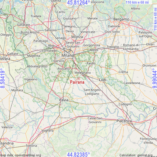
Pairana GPS coordinates[2]
45° 19' 13.44" North, 9° 17' 14.352" East
| Map corner | latitude | longitude |
|---|---|---|
| Upper-left | 45.81264°, | 8.58419° |
| Center: | 45.3204°, | 9.28732° |
| Lower-right: | 44.82385°, | 9.99044° |
| Map W x H: | 109.9×109.9 km | = 68.3×68.3mi |
| max Lat: | 47.04031° ⇑32% North |
| Pairana: | 45.3204° |
| min Lat: | ⇓68% South 35.50142° |
| min Long | Pairana | max Long |
| 6.69888° | 9.28732° | 18.48682° |
| W 23.4%⇐ | ⇒76.6% E |
Elevation
Elevation of Pairana is 88 m = 289 ft, and this is 218.7 m = 718 ft below average elevation for this country.
| Max E: |
2085 m = 6841 ft | 72% |
| Avg. | 306.7 m = 1006 ft | |
| Pairana | 88 m = 289 ft | |
Min E: |
-4 m = -13 ft | 28% |
See also: Italy elevation on elevation.city.
Geographical zone
Pairana is located in North temperate zone (between Tropic of Cancer and the Arctic Circle). Distance of this North polar circle is 2362 km =1467.7 mi to North.| Distance of | km | miles | from Pairana |
|---|---|---|---|
| North Pole | 4967.9 | 3086.9 | to North |
| Arctic Circle | 2362 | 1467.7 | to North |
| Tropic Cancer | 2433.2 | 1511.9 | to South |
| Equator | 5039.2 | 3131.2 | to South |


Nearby cities:
15 places around Pairana: (largest is in red/bold)
• Bascapè
2.6 km =1.6 mi,  127°
127°
• Carpiano
2.4 km =1.5 mi,  334°
334°
• Cerro al Lambro
4.2 km =2.6 mi,  75°
75°
• Landriano
2.3 km =1.4 mi,  244°
244°
• Locate di Triulzi
6.3 km =3.9 mi,  309°
309°
• Mairano
5.7 km =3.5 mi,  101°
101°
• Melegnano
5 km =3.1 mi,  34°
34°
• Quartiere Sarmazzano
6.5 km =4 mi,  38°
38°
• Riozzo
3.9 km =2.4 mi, 43°
• San Zenone al Lambro
5.4 km =3.4 mi, 82°
• Torrevecchia Pia
4.3 km =2.7 mi,  170°
170°
• Vidigulfo
5.1 km =3.2 mi,  232°
232°
• Vigonzone
5.5 km =3.4 mi,  161°
161°
• Vizzolo Predabissi
6.2 km =3.9 mi,  50°
50°
• Zibido al Lambro
4.7 km =2.9 mi,  192°
192°
Sources, notices
• [Note1] Compared only with cities in Italy existing in our database
• [Src1] Map data: © OpenStreetMap contributors (CC-BY-SA)
• [Src2] Other city data from geonames.org with taken over terms of usage.
• [Src3] Geographical zone / Annual Mean Temperature by Robert A. Rohde @ Wikipedia
