Siziano geodata
Siziano (Lombardy) is a seat of a third-order administrative division; located in Italy in Europe/Rome (GMT+2) time zone. With population of 5,244 people, there are 1860 cities with bigger population in this country. Compared to other cities in Italy, 67.9% of cities are located further ↓South; 78% of cities are located further →East and 71.5% of cities have higher elevation than Siziano. Note1


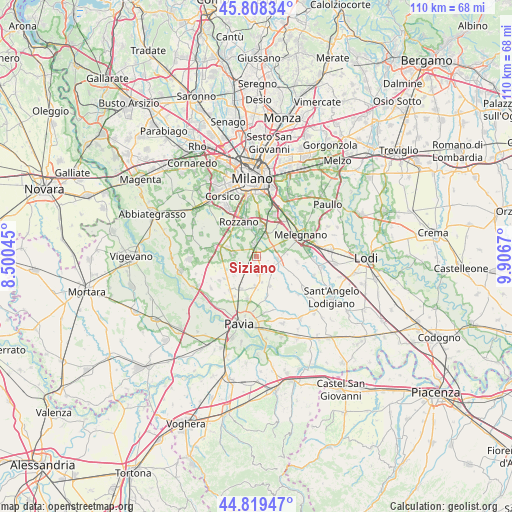
Siziano GPS coordinates[2]
45° 18' 57.816" North, 9° 12' 12.852" East
| Map corner | latitude | longitude |
|---|---|---|
| Upper-left | 45.80834°, | 8.50045° |
| Center: | 45.31606°, | 9.20357° |
| Lower-right: | 44.81947°, | 9.9067° |
| Map W x H: | 110×110 km | = 68.4×68.4mi |
| max Lat: | 47.04031° ⇑32.1% North |
| Siziano: | 45.31606° |
| min Lat: | ⇓67.9% South 35.50142° |
| min Long | Siziano | max Long |
| 6.69888° | 9.20357° | 18.48682° |
| W 22%⇐ | ⇒78% E |
Elevation
Elevation of Siziano is 90 m = 295 ft, and this is 216.7 m = 711 ft below average elevation for this country.
| Max E: |
2085 m = 6841 ft | 71.5% |
| Avg. | 306.7 m = 1006 ft | |
| Siziano | 90 m = 295 ft | |
Min E: |
-4 m = -13 ft | 28.5% |
See also: Italy elevation on elevation.city.
Geographical zone
Siziano is located in North temperate zone (between Tropic of Cancer and the Arctic Circle). Distance of this North polar circle is 2362.5 km =1468 mi to North.| Distance of | km | miles | from Siziano |
|---|---|---|---|
| North Pole | 4968.4 | 3087.2 | to North |
| Arctic Circle | 2362.5 | 1468 | to North |
| Tropic Cancer | 2432.8 | 1511.7 | to South |
| Equator | 5038.7 | 3130.9 | to South |


Nearby cities:
15 places around Siziano: (largest is in red/bold)
• Basiglio
5.9 km =3.7 mi,  323°
323°
• Bornasco
5.6 km =3.5 mi,  168°
168°
• Carpiano
6.1 km =3.8 mi,  63°
63°
• Fizzonasco
6.3 km =3.9 mi,  350°
350°
• Giussago
6.1 km =3.8 mi,  234°
234°
• Gualdrasco
4 km =2.5 mi,  179°
179°
• Lacchiarella
5.2 km =3.2 mi,  278°
278°
• Landriano
4.5 km =2.8 mi,  96°
96°
• Locate di Triulzi
4.8 km =3 mi,  20°
20°
• Opera
6.4 km =4 mi,  5°
5°
• Pairana
6.6 km =4.1 mi,  85°
85°
• Pieve Emanuele
3.8 km =2.4 mi,  358°
358°
• Turago Bordone
3.8 km =2.4 mi, 227°
• Vidigulfo
3.6 km =2.2 mi,  136°
136°
• Zeccone
6.5 km =4 mi, 181°
Sources, notices
• [Note1] Compared only with cities in Italy existing in our database
• [Src1] Map data: © OpenStreetMap contributors (CC-BY-SA)
• [Src2] Other city data from geonames.org with taken over terms of usage.
• [Src3] Geographical zone / Annual Mean Temperature by Robert A. Rohde @ Wikipedia
