Torrevecchia Pia geodata
Torrevecchia Pia (Lombardy) is a seat of a third-order administrative division; located in Italy in Europe/Rome (GMT+2) time zone. With population of 1,505 people, there are 5104 cities with bigger population in this country. Compared to other cities in Italy, 67% of cities are located further ↓South; 76.4% of cities are located further →East and 72.3% of cities have higher elevation than Torrevecchia Pia. Note1


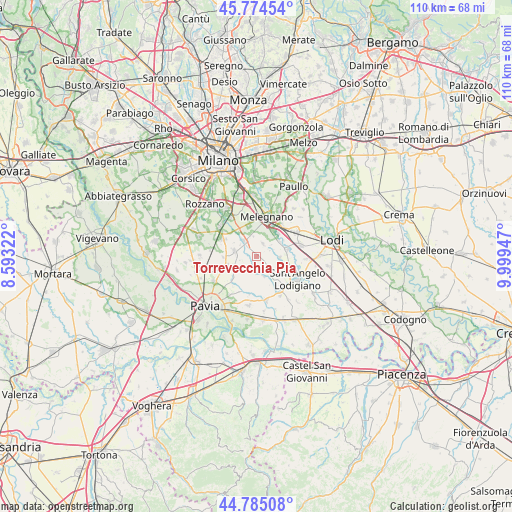
Torrevecchia Pia GPS coordinates[2]
45° 16' 55.092" North, 9° 17' 46.86" East
| Map corner | latitude | longitude |
|---|---|---|
| Upper-left | 45.77454°, | 8.59322° |
| Center: | 45.28197°, | 9.29635° |
| Lower-right: | 44.78508°, | 9.99947° |
| Map W x H: | 110×110 km | = 68.4×68.4mi |
| max Lat: | 47.04031° ⇑33% North |
| Torrevecchia Pia: | 45.28197° |
| min Lat: | ⇓67% South 35.50142° |
| min Long | Torrevecchia Pi | max Long |
| 6.69888° | 9.29635° | 18.48682° |
| W 23.6%⇐ | ⇒76.4% E |
Elevation
Elevation of Torrevecchia Pia is 86 m = 282 ft, and this is 220.7 m = 724 ft below average elevation for this country.
| Max E: |
2085 m = 6841 ft | 72.3% |
| Avg. | 306.7 m = 1006 ft | |
| Torrevecchia Pia | 86 m = 282 ft | |
Min E: |
-4 m = -13 ft | 27.7% |
See also: Italy elevation on elevation.city.
Geographical zone
Torrevecchia Pia is located in North temperate zone (between Tropic of Cancer and the Arctic Circle). Distance of this North polar circle is 2366.3 km =1470.4 mi to North.| Distance of | km | miles | from Torrevecchia Pia |
|---|---|---|---|
| North Pole | 4972.2 | 3089.6 | to North |
| Arctic Circle | 2366.3 | 1470.4 | to North |
| Tropic Cancer | 2429 | 1509.3 | to South |
| Equator | 5034.9 | 3128.5 | to South |


Nearby cities:
15 places around Torrevecchia Pia: (largest is in red/bold)
• Bascapè
3 km =1.9 mi,  27°
27°
• Casaletto Lodigiano
5.3 km =3.3 mi,  76°
76°
• Caselle Lurani
5 km =3.1 mi,  91°
91°
• Ceranova
4.8 km =3 mi,  239°
239°
• Cerro al Lambro
6.3 km =3.9 mi, 32°
• Landriano
4.3 km =2.7 mi,  319°
319°
• Mairano
5.8 km =3.6 mi,  57°
57°
• Marzano
3.8 km =2.4 mi,  181°
181°
• Pairana
4.3 km =2.7 mi,  350°
350°
• Roncaro
6.2 km =3.9 mi,  195°
195°
• Torre d'Arese
4.7 km =2.9 mi,  159°
159°
• Valera Fratta
4.2 km =2.6 mi,  131°
131°
• Vidigulfo
4.9 km =3 mi,  283°
283°
• Vigonzone
1.4 km =0.9 mi, 131°
• Zibido al Lambro
1.8 km =1.1 mi,  260°
260°
Sources, notices
• [Note1] Compared only with cities in Italy existing in our database
• [Src1] Map data: © OpenStreetMap contributors (CC-BY-SA)
• [Src2] Other city data from geonames.org with taken over terms of usage.
• [Src3] Geographical zone / Annual Mean Temperature by Robert A. Rohde @ Wikipedia
