Landiona geodata
Landiona (Piedmont) is a seat of a third-order administrative division; located in Italy in Europe/Rome (GMT+2) time zone. With population of 575 people, there are 9221 cities with bigger population in this country. Compared to other cities in Italy, 73.5% of cities are located further ↓South; 88.8% of cities are located further →East and 57.5% of cities have higher elevation than Landiona. Note1


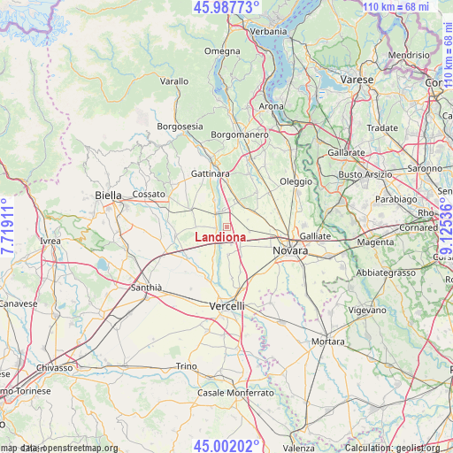
Landiona GPS coordinates[2]
45° 29' 49.308" North, 8° 25' 20.064" East
| Map corner | latitude | longitude |
|---|---|---|
| Upper-left | 45.98773°, | 7.71911° |
| Center: | 45.49703°, | 8.42224° |
| Lower-right: | 45.00202°, | 9.12536° |
| Map W x H: | 109.6×109.6 km | = 68.1×68.1mi |
| max Lat: | 47.04031° ⇑26.5% North |
| Landiona: | 45.49703° |
| min Lat: | ⇓73.5% South 35.50142° |
| min Long | Landiona | max Long |
| 6.69888° | 8.42224° | 18.48682° |
| W 11.2%⇐ | ⇒88.8% E |
Elevation
Elevation of Landiona is 184 m = 604 ft, and this is 122.7 m = 403 ft below average elevation for this country.
| Max E: |
2085 m = 6841 ft | 57.5% |
| Avg. | 306.7 m = 1006 ft | |
| Landiona | 184 m = 604 ft | |
Min E: |
-4 m = -13 ft | 42.5% |
See also: Italy elevation on elevation.city.
Geographical zone
Landiona is located in North temperate zone (between Tropic of Cancer and the Arctic Circle). Distance of this North polar circle is 2342.4 km =1455.5 mi to North.| Distance of | km | miles | from Landiona |
|---|---|---|---|
| North Pole | 4948.3 | 3074.7 | to North |
| Arctic Circle | 2342.4 | 1455.5 | to North |
| Tropic Cancer | 2452.9 | 1524.2 | to South |
| Equator | 5058.8 | 3143.4 | to South |


Nearby cities:
15 places around Landiona: (largest is in red/bold)
• Arborio
2.7 km =1.7 mi,  267°
267°
• Biandrate
5.9 km =3.7 mi,  146°
146°
• Briona
6.8 km =4.2 mi,  41°
41°
• Carpignano Sesia
4.1 km =2.5 mi,  354°
354°
• Casaleggio Novara
5.6 km =3.5 mi,  100°
100°
• Castellazzo Novarese
5.4 km =3.4 mi,  70°
70°
• Fara Novarese
6.9 km =4.3 mi,  22°
22°
• Ghislarengo
4.5 km =2.8 mi,  320°
320°
• Greggio
5.8 km =3.6 mi,  209°
209°
• Lenta
7.3 km =4.5 mi,  335°
335°
• Mandello Vitta
2.9 km =1.8 mi,  92°
92°
• Recetto
4.3 km =2.7 mi,  166°
166°
• San Nazzaro Sesia
6.6 km =4.1 mi,  178°
178°
• Sillavengo
3 km =1.9 mi,  29°
29°
• Vicolungo
3.9 km =2.4 mi,  128°
128°
Sources, notices
• [Note1] Compared only with cities in Italy existing in our database
• [Src1] Map data: © OpenStreetMap contributors (CC-BY-SA)
• [Src2] Other city data from geonames.org with taken over terms of usage.
• [Src3] Geographical zone / Annual Mean Temperature by Robert A. Rohde @ Wikipedia
