Greggio geodata
Greggio (Piedmont) is a seat of a third-order administrative division; located in Italy in Europe/Rome (GMT+2) time zone. With population of 317 people, there are 10606 cities with bigger population in this country. Compared to other cities in Italy, 71.9% of cities are located further ↓South; 89.2% of cities are located further →East and 60.2% of cities have higher elevation than Greggio. Note1


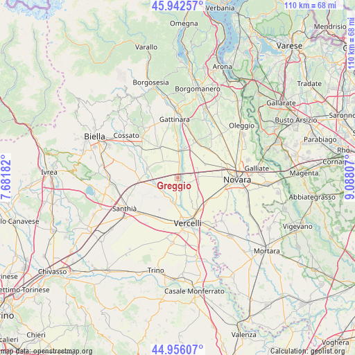
Greggio GPS coordinates[2]
45° 27' 5.328" North, 8° 23' 5.784" East
| Map corner | latitude | longitude |
|---|---|---|
| Upper-left | 45.94257°, | 7.68182° |
| Center: | 45.45148°, | 8.38494° |
| Lower-right: | 44.95607°, | 9.08807° |
| Map W x H: | 109.7×109.7 km | = 68.2×68.2mi |
| max Lat: | 47.04031° ⇑28.1% North |
| Greggio: | 45.45148° |
| min Lat: | ⇓71.9% South 35.50142° |
| min Long | Greggio | max Long |
| 6.69888° | 8.38494° | 18.48682° |
| W 10.8%⇐ | ⇒89.2% E |
Elevation
Elevation of Greggio is 162 m = 531 ft, and this is 144.7 m = 475 ft below average elevation for this country.
| Max E: |
2085 m = 6841 ft | 60.2% |
| Avg. | 306.7 m = 1006 ft | |
| Greggio | 162 m = 531 ft | |
Min E: |
-4 m = -13 ft | 39.8% |
See also: Italy elevation on elevation.city.
Geographical zone
Greggio is located in North temperate zone (between Tropic of Cancer and the Arctic Circle). Distance of this North polar circle is 2347.4 km =1458.6 mi to North.| Distance of | km | miles | from Greggio |
|---|---|---|---|
| North Pole | 4953.3 | 3077.8 | to North |
| Arctic Circle | 2347.4 | 1458.6 | to North |
| Tropic Cancer | 2447.8 | 1521 | to South |
| Equator | 5053.7 | 3140.2 | to South |


Nearby cities:
15 places around Greggio: (largest is in red/bold)
• Albano Vercellese
2.8 km =1.7 mi,  186°
186°
• Arborio
4.9 km =3 mi,  2°
2°
• Biandrate
6.2 km =3.9 mi,  88°
88°
• Casalbeltrame
6.5 km =4 mi,  103°
103°
• Collobiano
6.8 km =4.2 mi,  205°
205°
• Formigliana
7.7 km =4.8 mi,  251°
251°
• Landiona
5.8 km =3.6 mi,  29°
29°
• Mandello Vitta
7.6 km =4.7 mi,  49°
49°
• Oldenico
5.4 km =3.4 mi,  183°
183°
• Recetto
4 km =2.5 mi,  76°
76°
• San Giacomo Vercellese
6.9 km =4.3 mi,  318°
318°
• San Nazzaro Sesia
3.5 km =2.2 mi,  115°
115°
• Vicolungo
6.5 km =4 mi,  66°
66°
• Villarboit
4 km =2.5 mi, 247°
• Villata
8.1 km =5 mi,  152°
152°
Sources, notices
• [Note1] Compared only with cities in Italy existing in our database
• [Src1] Map data: © OpenStreetMap contributors (CC-BY-SA)
• [Src2] Other city data from geonames.org with taken over terms of usage.
• [Src3] Geographical zone / Annual Mean Temperature by Robert A. Rohde @ Wikipedia
