Lenta geodata
Lenta (Piedmont) is a seat of a third-order administrative division; located in Italy in Europe/Rome (GMT+2) time zone. With population of 816 people, there are 7564 cities with bigger population in this country. Compared to other cities in Italy, 75.5% of cities are located further ↓South; 89.3% of cities are located further →East and 51.6% of cities have higher elevation than Lenta. Note1


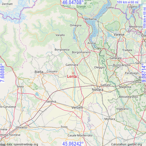
Lenta GPS coordinates[2]
45° 33' 24.876" North, 8° 23' 2.472" East
| Map corner | latitude | longitude |
|---|---|---|
| Upper-left | 46.04708°, | 7.68089° |
| Center: | 45.55691°, | 8.38402° |
| Lower-right: | 45.06242°, | 9.08714° |
| Map W x H: | 109.5×109.5 km | = 68×68mi |
| max Lat: | 47.04031° ⇑24.5% North |
| Lenta: | 45.55691° |
| min Lat: | ⇓75.5% South 35.50142° |
| min Long | Lenta | max Long |
| 6.69888° | 8.38402° | 18.48682° |
| W 10.7%⇐ | ⇒89.3% E |
Elevation
Elevation of Lenta is 224 m = 735 ft, and this is 82.7 m = 271 ft below average elevation for this country.
| Max E: |
2085 m = 6841 ft | 51.6% |
| Avg. | 306.7 m = 1006 ft | |
| Lenta | 224 m = 735 ft | |
Min E: |
-4 m = -13 ft | 48.4% |
See also: Italy elevation on elevation.city.
Geographical zone
Lenta is located in North temperate zone (between Tropic of Cancer and the Arctic Circle). Distance of this North polar circle is 2335.7 km =1451.3 mi to North.| Distance of | km | miles | from Lenta |
|---|---|---|---|
| North Pole | 4941.6 | 3070.6 | to North |
| Arctic Circle | 2335.7 | 1451.3 | to North |
| Tropic Cancer | 2459.5 | 1528.3 | to South |
| Equator | 5065.5 | 3147.6 | to South |


Nearby cities:
15 places around Lenta: (largest is in red/bold)
• Arborio
6.8 km =4.2 mi,  177°
177°
• Briona
7.6 km =4.7 mi,  102°
102°
• Carpignano Sesia
3.7 km =2.3 mi,  135°
135°
• Fara Novarese
5.7 km =3.5 mi,  92°
92°
• Gattinara
6.4 km =4 mi,  346°
346°
• Ghemme
5.4 km =3.4 mi,  31°
31°
• Ghislarengo
3.2 km =2 mi, 178°
• Landiona
7.3 km =4.5 mi,  155°
155°
• Lozzolo
8.4 km =5.2 mi,  325°
325°
• Mandello Vitta
9 km =5.6 mi, 139°
• Romagnano Sesia
8.4 km =5.2 mi,  1°
1°
• Rovasenda
5.7 km =3.5 mi,  249°
249°
• San Giacomo Vercellese
7.9 km =4.9 mi,  214°
214°
• Sillavengo
6 km =3.7 mi,  132°
132°
• Sizzano
4.6 km =2.9 mi,  61°
61°
Sources, notices
• [Note1] Compared only with cities in Italy existing in our database
• [Src1] Map data: © OpenStreetMap contributors (CC-BY-SA)
• [Src2] Other city data from geonames.org with taken over terms of usage.
• [Src3] Geographical zone / Annual Mean Temperature by Robert A. Rohde @ Wikipedia
