Ittiri geodata
Ittiri (Sardinia) is a seat of a third-order administrative division; located in Italy in Europe/Rome (GMT+2) time zone. With population of 8,781 people, there are 1083 cities with bigger population in this country. Compared to other cities in Italy, 83.5% of cities are located further ↑North; 87.1% of cities are located further →East and 69.9% of cities have lower elevation than Ittiri. Note1


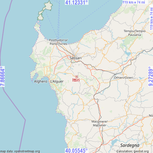
Ittiri GPS coordinates[2]
40° 35' 29.436" North, 8° 34' 11.136" East
| Map corner | latitude | longitude |
|---|---|---|
| Upper-left | 41.12331°, | 7.86664° |
| Center: | 40.59151°, | 8.56976° |
| Lower-right: | 40.05545°, | 9.27289° |
| Map W x H: | 118.7×118.7 km | = 73.8×73.8mi |
| max Lat: | 47.04031° ⇑83.5% North |
| Ittiri: | 40.59151° |
| min Lat: | ⇓16.5% South 35.50142° |
| min Long | Ittiri | max Long |
| 6.69888° | 8.56976° | 18.48682° |
| W 12.9%⇐ | ⇒87.1% E |
Elevation
Elevation of Ittiri is 393 m = 1289 ft, and this is 86.3 m = 283 ft above average elevation for this country.
| Max E: |
2085 m = 6841 ft | 30.1% |
| Ittiri | 393 m 1289 ft | |
| Avg. | 306.7 m = 1006 ft | |
Min E: |
-4 m = -13 ft | 69.9% |
See also: Italy elevation on elevation.city.
Geographical zone
Ittiri is located in North temperate zone (between Tropic of Cancer and the Arctic Circle). Distance of this Northern Tropic circle is 1907.4 km =1185.2 mi to South.| Distance of | km | miles | from Ittiri |
|---|---|---|---|
| North Pole | 5493.7 | 3413.6 | to North |
| Arctic Circle | 2887.8 | 1794.4 | to North |
| Tropic Cancer | 1907.4 | 1185.2 | to South |
| Equator | 4513.4 | 2804.5 | to South |


Nearby cities:
15 places around Ittiri: (largest is in red/bold)
• Banari
11.3 km =7 mi,  101°
101°
• Bessude
13.9 km =8.6 mi,  107°
107°
• Cargeghe
9.4 km =5.8 mi,  24°
24°
• Codrongianos
11.8 km =7.3 mi,  52°
52°
• Florinas
10.3 km =6.4 mi, 51°
• Monteleone Rocca Doria
13.3 km =8.3 mi,  183°
183°
• Muros
10.5 km =6.5 mi, 22°
• Ossi
9.5 km =5.9 mi,  11°
11°
• Putifigari
9.8 km =6.1 mi,  250°
250°
• Romana
12 km =7.5 mi,  173°
173°
• Siligo
13.5 km =8.4 mi, 97°
• Tissi
9.7 km =6 mi,  355°
355°
• Uri
8.6 km =5.3 mi,  307°
307°
• Usini
8.5 km =5.3 mi,  342°
342°
• Villanova Monteleone
12.9 km =8 mi,  220°
220°
Sources, notices
• [Note1] Compared only with cities in Italy existing in our database
• [Src1] Map data: © OpenStreetMap contributors (CC-BY-SA)
• [Src2] Other city data from geonames.org with taken over terms of usage.
• [Src3] Geographical zone / Annual Mean Temperature by Robert A. Rohde @ Wikipedia
