Ossi geodata
Ossi (Sardinia) is a seat of a third-order administrative division; located in Italy in Europe/Rome (GMT+2) time zone. With population of 5,713 people, there are 1719 cities with bigger population in this country. Compared to other cities in Italy, 82.6% of cities are located further ↑North; 86.8% of cities are located further →East and 62.8% of cities have lower elevation than Ossi. Note1


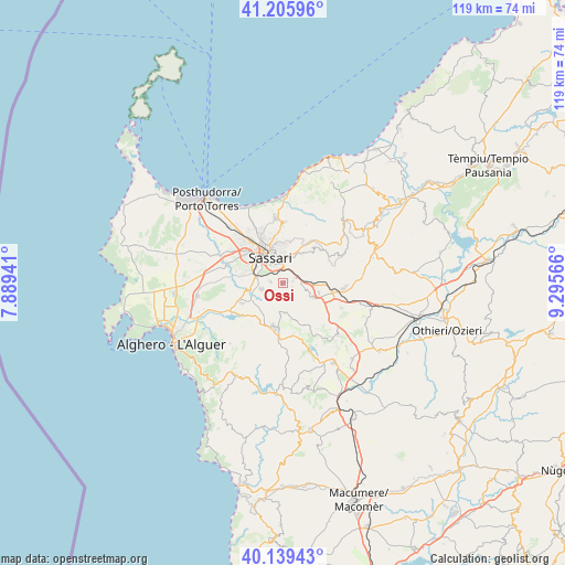
Ossi GPS coordinates[2]
40° 40' 29.388" North, 8° 35' 33.144" East
| Map corner | latitude | longitude |
|---|---|---|
| Upper-left | 41.20596°, | 7.88941° |
| Center: | 40.67483°, | 8.59254° |
| Lower-right: | 40.13943°, | 9.29566° |
| Map W x H: | 118.6×118.6 km | = 73.7×73.7mi |
| max Lat: | 47.04031° ⇑82.6% North |
| Ossi: | 40.67483° |
| min Lat: | ⇓17.4% South 35.50142° |
| min Long | Ossi | max Long |
| 6.69888° | 8.59254° | 18.48682° |
| W 13.2%⇐ | ⇒86.8% E |
Elevation
Elevation of Ossi is 321 m = 1053 ft, and this is 14.3 m = 47 ft above average elevation for this country.
| Max E: |
2085 m = 6841 ft | 37.2% |
| Ossi | 321 m 1053 ft | |
| Avg. | 306.7 m = 1006 ft | |
Min E: |
-4 m = -13 ft | 62.8% |
See also: Italy elevation on elevation.city.
Geographical zone
Ossi is located in North temperate zone (between Tropic of Cancer and the Arctic Circle). Distance of this Northern Tropic circle is 1916.7 km =1191 mi to South.| Distance of | km | miles | from Ossi |
|---|---|---|---|
| North Pole | 5484.4 | 3407.8 | to North |
| Arctic Circle | 2878.6 | 1788.7 | to North |
| Tropic Cancer | 1916.7 | 1191 | to South |
| Equator | 4522.6 | 2810.2 | to South |


Nearby cities:
15 places around Ossi: (largest is in red/bold)
• Bancali
12.8 km =8 mi,  301°
301°
• Cargeghe
2 km =1.2 mi,  108°
108°
• Codrongianos
7.8 km =4.8 mi, 105°
• Florinas
6.8 km =4.2 mi,  115°
115°
• Ittiri
9.5 km =5.9 mi,  191°
191°
• Li Punti-San Giovanni
13.2 km =8.2 mi,  318°
318°
• Muros
2.2 km =1.4 mi,  77°
77°
• Osilo
10.1 km =6.3 mi,  40°
40°
• Ploaghe
13.3 km =8.3 mi,  91°
91°
• Sassari
6.5 km =4 mi,  331°
331°
• Sennori
12.6 km =7.8 mi,  0°
0°
• Sorso
13.9 km =8.6 mi,  354°
354°
• Tissi
2.7 km =1.7 mi,  278°
278°
• Uri
9.6 km =6 mi,  245°
245°
• Usini
4.7 km =2.9 mi,  255°
255°
Sources, notices
• [Note1] Compared only with cities in Italy existing in our database
• [Src1] Map data: © OpenStreetMap contributors (CC-BY-SA)
• [Src2] Other city data from geonames.org with taken over terms of usage.
• [Src3] Geographical zone / Annual Mean Temperature by Robert A. Rohde @ Wikipedia
