Florinas geodata
Florinas (Sardinia) is a seat of a third-order administrative division; located in Italy in Europe/Rome (GMT+2) time zone. With population of 1,341 people, there are 5509 cities with bigger population in this country. Compared to other cities in Italy, 83% of cities are located further ↑North; 86% of cities are located further →East and 71.7% of cities have lower elevation than Florinas. Note1


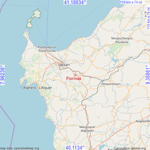
Florinas GPS coordinates[2]
40° 38' 56.4" North, 8° 39' 55.728" East
| Map corner | latitude | longitude |
|---|---|---|
| Upper-left | 41.18034°, | 7.96236° |
| Center: | 40.649°, | 8.66548° |
| Lower-right: | 40.1134°, | 9.36861° |
| Map W x H: | 118.6×118.6 km | = 73.7×73.7mi |
| max Lat: | 47.04031° ⇑83% North |
| Florinas: | 40.649° |
| min Lat: | ⇓17% South 35.50142° |
| min Long | Florinas | max Long |
| 6.69888° | 8.66548° | 18.48682° |
| W 14%⇐ | ⇒86% E |
Elevation
Elevation of Florinas is 412 m = 1352 ft, and this is 105.3 m = 345 ft above average elevation for this country.
| Max E: |
2085 m = 6841 ft | 28.3% |
| Florinas | 412 m 1352 ft | |
| Avg. | 306.7 m = 1006 ft | |
Min E: |
-4 m = -13 ft | 71.7% |
See also: Italy elevation on elevation.city.
Geographical zone
Florinas is located in North temperate zone (between Tropic of Cancer and the Arctic Circle). Distance of this Northern Tropic circle is 1913.8 km =1189.2 mi to South.| Distance of | km | miles | from Florinas |
|---|---|---|---|
| North Pole | 5487.3 | 3409.6 | to North |
| Arctic Circle | 2881.4 | 1790.4 | to North |
| Tropic Cancer | 1913.8 | 1189.2 | to South |
| Equator | 4519.7 | 2808.4 | to South |


Nearby cities:
15 places around Florinas: (largest is in red/bold)
• Ardara
12.6 km =7.8 mi,  104°
104°
• Banari
9.2 km =5.7 mi,  161°
161°
• Bessude
11.7 km =7.3 mi,  153°
153°
• Cargeghe
4.8 km =3 mi,  297°
297°
• Codrongianos
1.6 km =1 mi,  59°
59°
• Ittiri
10.3 km =6.4 mi,  231°
231°
• Muros
5.2 km =3.2 mi,  309°
309°
• Osilo
10.5 km =6.5 mi,  2°
2°
• Ossi
6.8 km =4.2 mi, 295°
• Ploaghe
7.5 km =4.7 mi,  71°
71°
• Sassari
12.6 km =7.8 mi, 312°
• Siligo
9.8 km =6.1 mi, 147°
• Thiesi
14.6 km =9.1 mi, 161°
• Tissi
9.4 km =5.8 mi,  290°
290°
• Usini
10.8 km =6.7 mi,  278°
278°
Sources, notices
• [Note1] Compared only with cities in Italy existing in our database
• [Src1] Map data: © OpenStreetMap contributors (CC-BY-SA)
• [Src2] Other city data from geonames.org with taken over terms of usage.
• [Src3] Geographical zone / Annual Mean Temperature by Robert A. Rohde @ Wikipedia
