Siligo geodata
Siligo (Sardinia) is a seat of a third-order administrative division; located in Italy in Europe/Rome (GMT+2) time zone. With population of 877 people, there are 7282 cities with bigger population in this country. Compared to other cities in Italy, 83.6% of cities are located further ↑North; 85.1% of cities are located further →East and 71.3% of cities have lower elevation than Siligo. Note1


Siligo GPS coordinates[2]
40° 34' 29.388" North, 8° 43' 42.06" East
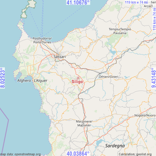
| Map corner | latitude | longitude |
|---|---|---|
| Upper-left | 41.10676°, | 8.02523° |
| Center: | 40.57483°, | 8.72835° |
| Lower-right: | 40.03864°, | 9.43148° |
| Map W x H: | 118.8×118.8 km | = 73.8×73.8mi |
| max Lat: | 47.04031° ⇑83.6% North |
| Siligo: | 40.57483° |
| min Lat: | ⇓16.4% South 35.50142° |
| min Long | Siligo | max Long |
| 6.69888° | 8.72835° | 18.48682° |
| W 14.9%⇐ | ⇒85.1% E |
Elevation
Elevation of Siligo is 407 m = 1335 ft, and this is 100.3 m = 329 ft above average elevation for this country.
| Max E: |
2085 m = 6841 ft | 28.7% |
| Siligo | 407 m 1335 ft | |
| Avg. | 306.7 m = 1006 ft | |
Min E: |
-4 m = -13 ft | 71.3% |
See also: Italy elevation on elevation.city.
Geographical zone
Siligo is located in North temperate zone (between Tropic of Cancer and the Arctic Circle). Distance of this Northern Tropic circle is 1905.6 km =1184.1 mi to South.| Distance of | km | miles | from Siligo |
|---|---|---|---|
| North Pole | 5495.6 | 3414.8 | to North |
| Arctic Circle | 2889.7 | 1795.6 | to North |
| Tropic Cancer | 1905.6 | 1184.1 | to South |
| Equator | 4511.5 | 2803.3 | to South |


Nearby cities:
15 places around Siligo: (largest is in red/bold)
• Ardara
8.6 km =5.3 mi,  53°
53°
• Banari
2.4 km =1.5 mi,  258°
258°
• Bessude
2.3 km =1.4 mi,  181°
181°
• Bonnanaro
5.6 km =3.5 mi,  147°
147°
• Borutta
6 km =3.7 mi,  167°
167°
• Cargeghe
14.2 km =8.8 mi,  317°
317°
• Cheremule
7.8 km =4.8 mi, 181°
• Codrongianos
9.9 km =6.2 mi,  336°
336°
• Florinas
9.8 km =6.1 mi,  327°
327°
• Giave
13.8 km =8.6 mi, 171°
• Ittiri
13.5 km =8.4 mi,  277°
277°
• Mores
9.4 km =5.8 mi,  108°
108°
• Ploaghe
10.8 km =6.7 mi,  9°
9°
• Thiesi
5.7 km =3.5 mi,  187°
187°
• Torralba
7.6 km =4.7 mi,  155°
155°
Sources, notices
• [Note1] Compared only with cities in Italy existing in our database
• [Src1] Map data: © OpenStreetMap contributors (CC-BY-SA)
• [Src2] Other city data from geonames.org with taken over terms of usage.
• [Src3] Geographical zone / Annual Mean Temperature by Robert A. Rohde @ Wikipedia
