Isola del Liri geodata
Isola del Liri (Latium) is a seat of a third-order administrative division; located in Italy in Europe/Rome (GMT+2) time zone. With population of 10,805 people, there are 878 cities with bigger population in this country. Compared to other cities in Italy, 73% of cities are located further ↑North; 74.6% of cities are located further ←West and 56.2% of cities have lower elevation than Isola del Liri. Note1


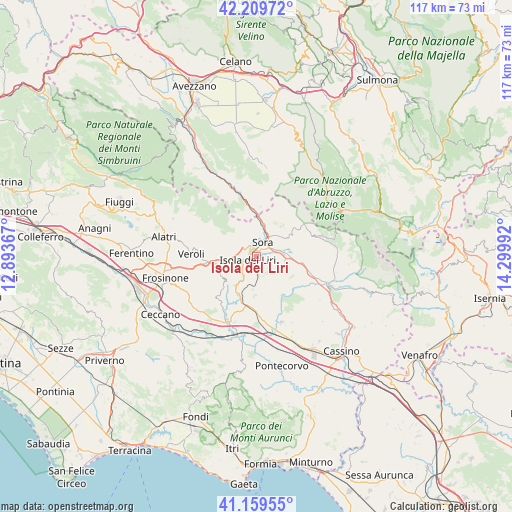
Isola del Liri GPS coordinates[2]
41° 41' 12.408" North, 13° 35' 48.444" East
| Map corner | latitude | longitude |
|---|---|---|
| Upper-left | 42.20972°, | 12.89367° |
| Center: | 41.68678°, | 13.59679° |
| Lower-right: | 41.15955°, | 14.29992° |
| Map W x H: | 116.8×116.8 km | = 72.6×72.6mi |
| max Lat: | 47.04031° ⇑73% North |
| Isola del Liri: | 41.68678° |
| min Lat: | ⇓27% South 35.50142° |
| min Long | Isola del Liri | max Long |
| 6.69888° | 13.59679° | 18.48682° |
| W 74.6%⇐ | ⇒25.4% E |
Elevation
Elevation of Isola del Liri is 273 m = 896 ft, and this is 33.7 m = 111 ft below average elevation for this country.
| Max E: |
2085 m = 6841 ft | 43.8% |
| Avg. | 306.7 m = 1006 ft | |
| Isola del Liri | 273 m = 896 ft | |
Min E: |
-4 m = -13 ft | 56.2% |
See also: Italy elevation on elevation.city.
Geographical zone
Isola del Liri is located in North temperate zone (between Tropic of Cancer and the Arctic Circle). Distance of this Northern Tropic circle is 2029.2 km =1260.9 mi to South.| Distance of | km | miles | from Isola del Liri |
|---|---|---|---|
| North Pole | 5371.9 | 3337.9 | to North |
| Arctic Circle | 2766 | 1718.7 | to North |
| Tropic Cancer | 2029.2 | 1260.9 | to South |
| Equator | 4635.1 | 2880.1 | to South |


Nearby cities:
15 places around Isola del Liri: (largest is in red/bold)
• Anitrella-Chiaiamari
6.7 km =4.2 mi,  216°
216°
• Arpino
4.6 km =2.9 mi,  164°
164°
• Broccostella
3.5 km =2.2 mi,  65°
65°
• Campoli Appennino
9 km =5.6 mi,  53°
53°
• Carnello
1.2 km =0.7 mi,  111°
111°
• Castelliri
4.8 km =3 mi,  257°
257°
• Collefontana-Fontana Liri Inferiore
9.2 km =5.7 mi,  205°
205°
• Fontechiari
6.8 km =4.2 mi, 107°
• Girate
7.5 km =4.7 mi, 220°
• Monte San Giovanni Campano
8.6 km =5.3 mi,  235°
235°
• Pescosolido
8.5 km =5.3 mi,  35°
35°
• Porrino
7.2 km =4.5 mi, 258°
• Posta Fibreno
6.9 km =4.3 mi,  85°
85°
• Sora
3.8 km =2.4 mi,  21°
21°
• Vicalvi
9.3 km =5.8 mi,  95°
95°
Sources, notices
• [Note1] Compared only with cities in Italy existing in our database
• [Src1] Map data: © OpenStreetMap contributors (CC-BY-SA)
• [Src2] Other city data from geonames.org with taken over terms of usage.
• [Src3] Geographical zone / Annual Mean Temperature by Robert A. Rohde @ Wikipedia
