Vicalvi geodata
Vicalvi (Latium) is a seat of a third-order administrative division; located in Italy in Europe/Rome (GMT+2) time zone. With population of 539 people, there are 9552 cities with bigger population in this country. Compared to other cities in Italy, 73.1% of cities are located further ↑North; 75.7% of cities are located further ←West and 73.1% of cities have lower elevation than Vicalvi. Note1


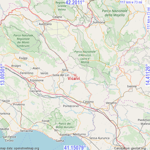
Vicalvi GPS coordinates[2]
41° 40' 41.124" North, 13° 42' 29.268" East
| Map corner | latitude | longitude |
|---|---|---|
| Upper-left | 42.2011°, | 13.00501° |
| Center: | 41.67809°, | 13.70813° |
| Lower-right: | 41.15079°, | 14.41126° |
| Map W x H: | 116.8×116.8 km | = 72.6×72.6mi |
| max Lat: | 47.04031° ⇑73.1% North |
| Vicalvi: | 41.67809° |
| min Lat: | ⇓26.9% South 35.50142° |
| min Long | Vicalvi | max Long |
| 6.69888° | 13.70813° | 18.48682° |
| W 75.7%⇐ | ⇒24.3% E |
Elevation
Elevation of Vicalvi is 427 m = 1401 ft, and this is 120.3 m = 395 ft above average elevation for this country.
| Max E: |
2085 m = 6841 ft | 26.9% |
| Vicalvi | 427 m 1401 ft | |
| Avg. | 306.7 m = 1006 ft | |
Min E: |
-4 m = -13 ft | 73.1% |
See also: Italy elevation on elevation.city.
Geographical zone
Vicalvi is located in North temperate zone (between Tropic of Cancer and the Arctic Circle). Distance of this Northern Tropic circle is 2028.3 km =1260.3 mi to South.| Distance of | km | miles | from Vicalvi |
|---|---|---|---|
| North Pole | 5372.9 | 3338.6 | to North |
| Arctic Circle | 2767 | 1719.3 | to North |
| Tropic Cancer | 2028.3 | 1260.3 | to South |
| Equator | 4634.2 | 2879.6 | to South |


Nearby cities:
15 places around Vicalvi: (largest is in red/bold)
• Alvito
3.6 km =2.2 mi,  68°
68°
• Arpino
8.7 km =5.4 mi,  246°
246°
• Atina Inferiore
9 km =5.6 mi,  128°
128°
• Broccostella
6.5 km =4 mi,  291°
291°
• Campoli Appennino
6.7 km =4.2 mi,  342°
342°
• Carnello
8.1 km =5 mi,  273°
273°
• Casalattico
6.4 km =4 mi,  166°
166°
• Casalvieri
5 km =3.1 mi, 174°
• Fontechiari
3 km =1.9 mi, 247°
• Gallinaro
7.9 km =4.9 mi,  108°
108°
• Isola del Liri
9.3 km =5.8 mi,  275°
275°
• Pescosolido
8.9 km =5.5 mi,  331°
331°
• Posta Fibreno
2.8 km =1.7 mi,  303°
303°
• San Donato Val di Comino
9.2 km =5.7 mi, 69°
• Sora
9 km =5.6 mi, 299°
Sources, notices
• [Note1] Compared only with cities in Italy existing in our database
• [Src1] Map data: © OpenStreetMap contributors (CC-BY-SA)
• [Src2] Other city data from geonames.org with taken over terms of usage.
• [Src3] Geographical zone / Annual Mean Temperature by Robert A. Rohde @ Wikipedia
