Sora geodata
Sora (Latium) is a seat of a third-order administrative division; located in Italy in Europe/Rome (GMT+2) time zone. With population of 23,758 people, there are 348 cities with bigger population in this country. Compared to other cities in Italy, 72.7% of cities are located further ↑North; 74.8% of cities are located further ←West and 57.6% of cities have lower elevation than Sora. Note1


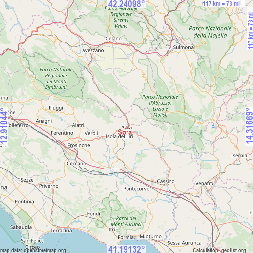
Sora GPS coordinates[2]
41° 43' 5.844" North, 13° 36' 48.816" East
| Map corner | latitude | longitude |
|---|---|---|
| Upper-left | 42.24098°, | 12.91044° |
| Center: | 41.71829°, | 13.61356° |
| Lower-right: | 41.19132°, | 14.31669° |
| Map W x H: | 116.7×116.7 km | = 72.5×72.5mi |
| max Lat: | 47.04031° ⇑72.7% North |
| Sora: | 41.71829° |
| min Lat: | ⇓27.3% South 35.50142° |
| min Long | Sora | max Long |
| 6.69888° | 13.61356° | 18.48682° |
| W 74.8%⇐ | ⇒25.2% E |
Elevation
Elevation of Sora is 283 m = 928 ft, and this is 23.7 m = 78 ft below average elevation for this country.
| Max E: |
2085 m = 6841 ft | 42.4% |
| Avg. | 306.7 m = 1006 ft | |
| Sora | 283 m = 928 ft | |
Min E: |
-4 m = -13 ft | 57.6% |
See also: Italy elevation on elevation.city.
Geographical zone
Sora is located in North temperate zone (between Tropic of Cancer and the Arctic Circle). Distance of this Northern Tropic circle is 2032.7 km =1263.1 mi to South.| Distance of | km | miles | from Sora |
|---|---|---|---|
| North Pole | 5368.4 | 3335.8 | to North |
| Arctic Circle | 2762.5 | 1716.5 | to North |
| Tropic Cancer | 2032.7 | 1263.1 | to South |
| Equator | 4638.6 | 2882.3 | to South |


Nearby cities:
15 places around Sora: (largest is in red/bold)
• Anitrella-Chiaiamari
10.4 km =6.5 mi,  211°
211°
• Arpino
7.9 km =4.9 mi,  181°
181°
• Balsorano
11.1 km =6.9 mi,  336°
336°
• Balsorano Nuovo
11 km =6.8 mi, 336°
• Broccostella
2.7 km =1.7 mi,  138°
138°
• Campoli Appennino
6.1 km =3.8 mi,  71°
71°
• Carnello
4 km =2.5 mi, 183°
• Castelliri
7.6 km =4.7 mi,  233°
233°
• Fontechiari
7.6 km =4.7 mi, 137°
• Isola del Liri
3.8 km =2.4 mi,  201°
201°
• Pescosolido
4.9 km =3 mi,  46°
46°
• Porrino
9.8 km =6.1 mi,  239°
239°
• Posta Fibreno
6.3 km =3.9 mi,  117°
117°
• Ridotti
7.7 km =4.8 mi,  355°
355°
• Vicalvi
9 km =5.6 mi, 119°
Sources, notices
• [Note1] Compared only with cities in Italy existing in our database
• [Src1] Map data: © OpenStreetMap contributors (CC-BY-SA)
• [Src2] Other city data from geonames.org with taken over terms of usage.
• [Src3] Geographical zone / Annual Mean Temperature by Robert A. Rohde @ Wikipedia
