Guiglia geodata
Guiglia (Emilia-Romagna) is a seat of a third-order administrative division; located in Italy in Europe/Rome (GMT+2) time zone. With population of 1,635 people, there are 4814 cities with bigger population in this country. Compared to other cities in Italy, 50.1% of cities are located further ↑North; 57.8% of cities are located further →East and 77.6% of cities have lower elevation than Guiglia. Note1


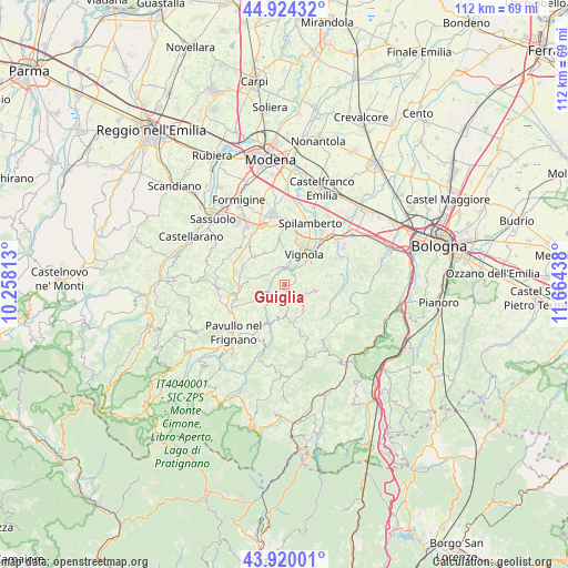
Guiglia GPS coordinates[2]
44° 25' 27.552" North, 10° 57' 40.5" East
| Map corner | latitude | longitude |
|---|---|---|
| Upper-left | 44.92432°, | 10.25813° |
| Center: | 44.42432°, | 10.96125° |
| Lower-right: | 43.92001°, | 11.66438° |
| Map W x H: | 111.7×111.7 km | = 69.4×69.4mi |
| max Lat: | 47.04031° ⇑50.1% North |
| Guiglia: | 44.42432° |
| min Lat: | ⇓49.9% South 35.50142° |
| min Long | Guiglia | max Long |
| 6.69888° | 10.96125° | 18.48682° |
| W 42.2%⇐ | ⇒57.8% E |
Elevation
Elevation of Guiglia is 487 m = 1598 ft, and this is 180.3 m = 592 ft above average elevation for this country.
| Max E: |
2085 m = 6841 ft | 22.4% |
| Guiglia | 487 m 1598 ft | |
| Avg. | 306.7 m = 1006 ft | |
Min E: |
-4 m = -13 ft | 77.6% |
See also: Italy elevation on elevation.city.
Geographical zone
Guiglia is located in North temperate zone (between Tropic of Cancer and the Arctic Circle). Distance of this Northern Tropic circle is 2333.6 km =1450 mi to South.| Distance of | km | miles | from Guiglia |
|---|---|---|---|
| North Pole | 5067.5 | 3148.8 | to North |
| Arctic Circle | 2461.7 | 1529.6 | to North |
| Tropic Cancer | 2333.6 | 1450 | to South |
| Equator | 4939.5 | 3069.3 | to South |


Nearby cities:
15 places around Guiglia: (largest is in red/bold)
• Castelletto
8.4 km =5.2 mi,  77°
77°
• Castelvetro di Modena
9 km =5.6 mi,  352°
352°
• Formica
6.4 km =4 mi,  40°
40°
• Garofano
4.9 km =3 mi, 39°
• Levizzano Rangone
7.9 km =4.9 mi,  329°
329°
• Marano sul Panaro
3.9 km =2.4 mi,  8°
8°
• Monteombraro
5.5 km =3.4 mi,  145°
145°
• Mulino
10.2 km =6.3 mi, 41°
• Rocca Malatina
4 km =2.5 mi,  175°
175°
• San Venanzio
11.7 km =7.3 mi,  315°
315°
• Savignano sul Panaro
8.6 km =5.3 mi, 43°
• Savigno
9.7 km =6 mi,  111°
111°
• Torre Maina
10.8 km =6.7 mi, 319°
• Vignola
7.7 km =4.8 mi,  30°
30°
• Zocca
9.1 km =5.7 mi,  163°
163°
Sources, notices
• [Note1] Compared only with cities in Italy existing in our database
• [Src1] Map data: © OpenStreetMap contributors (CC-BY-SA)
• [Src2] Other city data from geonames.org with taken over terms of usage.
• [Src3] Geographical zone / Annual Mean Temperature by Robert A. Rohde @ Wikipedia
