Castelletto geodata
Castelletto (Emilia-Romagna) is a seat of a third-order administrative division; located in Italy in Europe/Rome (GMT+2) time zone. With population of 2,125 people, there are 3958 cities with bigger population in this country. Compared to other cities in Italy, 50.2% of cities are located further ↓South; 56.4% of cities are located further →East and 57.3% of cities have higher elevation than Castelletto. Note1


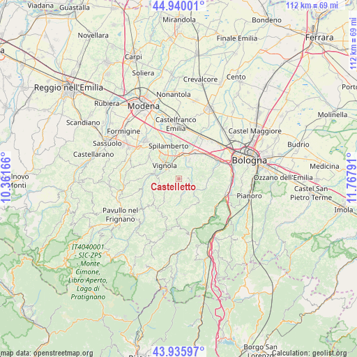
Castelletto GPS coordinates[2]
44° 26' 24.54" North, 11° 3' 53.208" East
| Map corner | latitude | longitude |
|---|---|---|
| Upper-left | 44.94001°, | 10.36166° |
| Center: | 44.44015°, | 11.06478° |
| Lower-right: | 43.93597°, | 11.76791° |
| Map W x H: | 111.6×111.6 km | = 69.3×69.3mi |
| max Lat: | 47.04031° ⇑49.8% North |
| Castelletto: | 44.44015° |
| min Lat: | ⇓50.2% South 35.50142° |
| min Long | Castelletto | max Long |
| 6.69888° | 11.06478° | 18.48682° |
| W 43.6%⇐ | ⇒56.4% E |
Elevation
Elevation of Castelletto is 185 m = 607 ft, and this is 121.7 m = 399 ft below average elevation for this country.
| Max E: |
2085 m = 6841 ft | 57.3% |
| Avg. | 306.7 m = 1006 ft | |
| Castelletto | 185 m = 607 ft | |
Min E: |
-4 m = -13 ft | 42.7% |
See also: Italy elevation on elevation.city.
Geographical zone
Castelletto is located in North temperate zone (between Tropic of Cancer and the Arctic Circle). Distance of this Northern Tropic circle is 2335.4 km =1451.1 mi to South.| Distance of | km | miles | from Castelletto |
|---|---|---|---|
| North Pole | 5065.8 | 3147.7 | to North |
| Arctic Circle | 2459.9 | 1528.5 | to North |
| Tropic Cancer | 2335.4 | 1451.1 | to South |
| Equator | 4941.3 | 3070.4 | to South |


Nearby cities:
15 places around Castelletto: (largest is in red/bold)
• Bazzano
7.1 km =4.4 mi,  14°
14°
• Crespellano
9.6 km =6 mi,  33°
33°
• Formica
5.1 km =3.2 mi,  307°
307°
• Garofano
5.5 km =3.4 mi,  292°
292°
• Guiglia
8.4 km =5.2 mi,  257°
257°
• Marano sul Panaro
7.9 km =4.9 mi, 285°
• Monte San Giovanni
8.8 km =5.5 mi,  104°
104°
• Monteombraro
8.1 km =5 mi,  219°
219°
• Montepastore
9.3 km =5.8 mi,  149°
149°
• Mulino
6 km =3.7 mi,  346°
346°
• Rocca Malatina
9.8 km =6.1 mi,  234°
234°
• Savignano sul Panaro
5.1 km =3.2 mi,  332°
332°
• Savigno
5.4 km =3.4 mi,  171°
171°
• Stiore
5.6 km =3.5 mi,  48°
48°
• Vignola
6.5 km =4 mi,  318°
318°
Sources, notices
• [Note1] Compared only with cities in Italy existing in our database
• [Src1] Map data: © OpenStreetMap contributors (CC-BY-SA)
• [Src2] Other city data from geonames.org with taken over terms of usage.
• [Src3] Geographical zone / Annual Mean Temperature by Robert A. Rohde @ Wikipedia
