Beinasco geodata
Beinasco (Piedmont) is a seat of a third-order administrative division; located in Italy in Europe/Rome (GMT+2) time zone. With population of 6,469 people, there are 1513 cities with bigger population in this country. Compared to other cities in Italy, 60.6% of cities are located further ↓South; 97.2% of cities are located further →East and 54.6% of cities have lower elevation than Beinasco. Note1


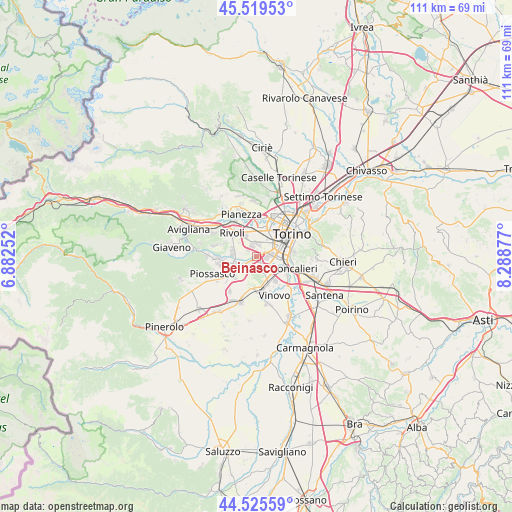
Beinasco GPS coordinates[2]
45° 1' 28.992" North, 7° 35' 8.304" East
| Map corner | latitude | longitude |
|---|---|---|
| Upper-left | 45.51953°, | 6.88252° |
| Center: | 45.02472°, | 7.58564° |
| Lower-right: | 44.52559°, | 8.28877° |
| Map W x H: | 110.5×110.5 km | = 68.7×68.7mi |
| max Lat: | 47.04031° ⇑39.4% North |
| Beinasco: | 45.02472° |
| min Lat: | ⇓60.6% South 35.50142° |
| min Long | Beinasco | max Long |
| 6.69888° | 7.58564° | 18.48682° |
| W 2.8%⇐ | ⇒97.2% E |
Elevation
Elevation of Beinasco is 263 m = 863 ft, and this is 43.7 m = 143 ft below average elevation for this country.
| Max E: |
2085 m = 6841 ft | 45.4% |
| Avg. | 306.7 m = 1006 ft | |
| Beinasco | 263 m = 863 ft | |
Min E: |
-4 m = -13 ft | 54.6% |
See also: Italy elevation on elevation.city.
Geographical zone
Beinasco is located in North temperate zone (between Tropic of Cancer and the Arctic Circle). Distance of this North polar circle is 2394.9 km =1488.1 mi to North.| Distance of | km | miles | from Beinasco |
|---|---|---|---|
| North Pole | 5000.8 | 3107.4 | to North |
| Arctic Circle | 2394.9 | 1488.1 | to North |
| Tropic Cancer | 2400.4 | 1491.5 | to South |
| Equator | 5006.3 | 3110.8 | to South |


Nearby cities:
15 places around Beinasco: (largest is in red/bold)
• Borgo Melano
1.2 km =0.7 mi,  215°
215°
• Candiolo
7.4 km =4.6 mi,  172°
172°
• Collegno
6.2 km =3.9 mi,  346°
346°
• Fornaci
1.1 km =0.7 mi,  69°
69°
• Garino
6.2 km =3.9 mi,  156°
156°
• Gerbido
3.1 km =1.9 mi,  45°
45°
• Gerbole
6.7 km =4.2 mi,  247°
247°
• Gerbole-Zucche
6.9 km =4.3 mi,  231°
231°
• Grugliasco
4.5 km =2.8 mi, 353°
• Lesna
4.3 km =2.7 mi,  39°
39°
• Nichelino
6 km =3.7 mi,  117°
117°
• Orbassano
4.3 km =2.7 mi,  240°
240°
• Pasta
3 km =1.9 mi, 240°
• Rivalta di Torino
5.2 km =3.2 mi,  279°
279°
• Tetti Neirotti
4.8 km =3 mi,  312°
312°
Sources, notices
• [Note1] Compared only with cities in Italy existing in our database
• [Src1] Map data: © OpenStreetMap contributors (CC-BY-SA)
• [Src2] Other city data from geonames.org with taken over terms of usage.
• [Src3] Geographical zone / Annual Mean Temperature by Robert A. Rohde @ Wikipedia
