Grizzana Morandi geodata
Grizzana Morandi (Emilia-Romagna) is a seat of a third-order administrative division; located in Italy in Europe/Rome (GMT+2) time zone. With population of 3,694 people, there are 2563 cities with bigger population in this country. Compared to other cities in Italy, 52.3% of cities are located further ↑North; 55.1% of cities are located further →East and 81.9% of cities have lower elevation than Grizzana Morandi. Note1


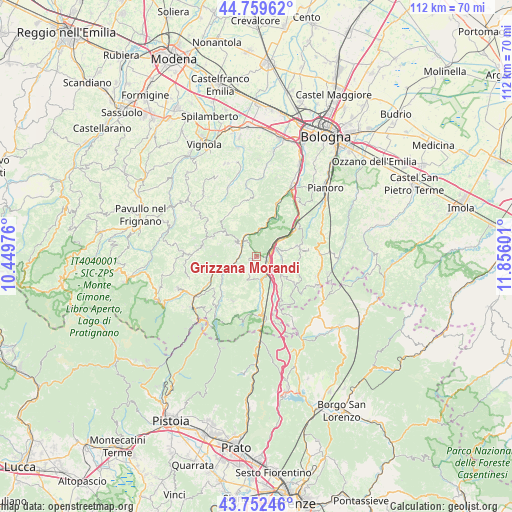
Grizzana Morandi GPS coordinates[2]
44° 15' 29.52" North, 11° 9' 10.368" East
| Map corner | latitude | longitude |
|---|---|---|
| Upper-left | 44.75962°, | 10.44976° |
| Center: | 44.2582°, | 11.15288° |
| Lower-right: | 43.75246°, | 11.85601° |
| Map W x H: | 112×112 km | = 69.6×69.6mi |
| max Lat: | 47.04031° ⇑52.3% North |
| Grizzana Morandi: | 44.2582° |
| min Lat: | ⇓47.7% South 35.50142° |
| min Long | Grizzana Morand | max Long |
| 6.69888° | 11.15288° | 18.48682° |
| W 44.9%⇐ | ⇒55.1% E |
Elevation
Elevation of Grizzana Morandi is 554 m = 1818 ft, and this is 247.3 m = 811 ft above average elevation for this country.
| Max E: |
2085 m = 6841 ft | 18.1% |
| Grizzana Morandi | 554 m 1818 ft | |
| Avg. | 306.7 m = 1006 ft | |
Min E: |
-4 m = -13 ft | 81.9% |
See also: Italy elevation on elevation.city.
Geographical zone
Grizzana Morandi is located in North temperate zone (between Tropic of Cancer and the Arctic Circle). Distance of this Northern Tropic circle is 2315.1 km =1438.5 mi to South.| Distance of | km | miles | from Grizzana Morandi |
|---|---|---|---|
| North Pole | 5086 | 3160.3 | to North |
| Arctic Circle | 2480.1 | 1541.1 | to North |
| Tropic Cancer | 2315.1 | 1438.5 | to South |
| Equator | 4921.1 | 3057.8 | to South |


Nearby cities:
15 places around Grizzana Morandi: (largest is in red/bold)
• Camugnano
11 km =6.8 mi,  207°
207°
• Grizzana
0.2 km =0.1 mi,  94°
94°
• Lagaro
5 km =3.1 mi,  155°
155°
• Marano
10 km =6.2 mi,  249°
249°
• Marzabotto
10.3 km =6.4 mi,  24°
24°
• Monzuno
9.3 km =5.8 mi,  76°
76°
• Pian di Venola
8.8 km =5.5 mi, 18°
• Piano del Voglio
11.2 km =7 mi,  153°
153°
• Pioppe di Salvaro
5.8 km =3.6 mi,  7°
7°
• Riola
8.2 km =5.1 mi, 247°
• Rioveggio
4.1 km =2.5 mi,  64°
64°
• San Benedetto Val di Sambro
8.2 km =5.1 mi,  126°
126°
• Tolè
10.8 km =6.7 mi,  317°
317°
• Vado
10.6 km =6.6 mi,  52°
52°
• Vergato
4.4 km =2.7 mi,  307°
307°
Sources, notices
• [Note1] Compared only with cities in Italy existing in our database
• [Src1] Map data: © OpenStreetMap contributors (CC-BY-SA)
• [Src2] Other city data from geonames.org with taken over terms of usage.
• [Src3] Geographical zone / Annual Mean Temperature by Robert A. Rohde @ Wikipedia
