Monzuno geodata
Monzuno (Emilia-Romagna) is a seat of a third-order administrative division; located in Italy in Europe/Rome (GMT+2) time zone. With population of 1,182 people, there are 6018 cities with bigger population in this country. Compared to other cities in Italy, 52.1% of cities are located further ↑North; 53.6% of cities are located further →East and 86.3% of cities have lower elevation than Monzuno. Note1


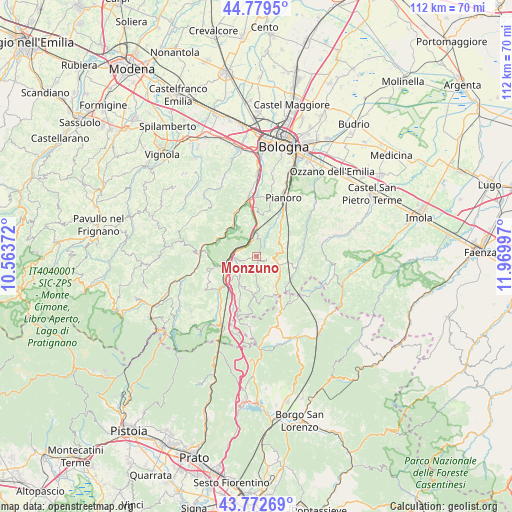
Monzuno GPS coordinates[2]
44° 16' 41.7" North, 11° 16' 0.624" East
| Map corner | latitude | longitude |
|---|---|---|
| Upper-left | 44.7795°, | 10.56372° |
| Center: | 44.27825°, | 11.26684° |
| Lower-right: | 43.77269°, | 11.96997° |
| Map W x H: | 111.9×111.9 km | = 69.5×69.5mi |
| max Lat: | 47.04031° ⇑52.1% North |
| Monzuno: | 44.27825° |
| min Lat: | ⇓47.9% South 35.50142° |
| min Long | Monzuno | max Long |
| 6.69888° | 11.26684° | 18.48682° |
| W 46.4%⇐ | ⇒53.6% E |
Elevation
Elevation of Monzuno is 638 m = 2093 ft, and this is 331.3 m = 1087 ft above average elevation for this country.
| Max E: |
2085 m = 6841 ft | 13.7% |
| Monzuno | 638 m 2093 ft | |
| Avg. | 306.7 m = 1006 ft | |
Min E: |
-4 m = -13 ft | 86.3% |
See also: Italy elevation on elevation.city.
Geographical zone
Monzuno is located in North temperate zone (between Tropic of Cancer and the Arctic Circle). Distance of this Northern Tropic circle is 2317.4 km =1440 mi to South.| Distance of | km | miles | from Monzuno |
|---|---|---|---|
| North Pole | 5083.8 | 3158.9 | to North |
| Arctic Circle | 2477.9 | 1539.7 | to North |
| Tropic Cancer | 2317.4 | 1440 | to South |
| Equator | 4923.3 | 3059.2 | to South |


Nearby cities:
15 places around Monzuno: (largest is in red/bold)
• Fontana
12 km =7.5 mi,  348°
348°
• Grizzana
9.1 km =5.7 mi,  255°
255°
• Grizzana Morandi
9.3 km =5.8 mi, 256°
• Lagaro
9.7 km =6 mi,  226°
226°
• Lama di Reno
10.6 km =6.6 mi,  337°
337°
• Loiano
5 km =3.1 mi,  103°
103°
• Marzabotto
8.7 km =5.4 mi,  326°
326°
• Monghidoro
7.6 km =4.7 mi,  143°
143°
• Monterenzio
12.2 km =7.6 mi,  63°
63°
• Pian di Venola
8.8 km =5.5 mi,  314°
314°
• Pioppe di Salvaro
9 km =5.6 mi,  292°
292°
• Rioveggio
5.4 km =3.4 mi,  265°
265°
• San Benedetto Val di Sambro
7.6 km =4.7 mi,  199°
199°
• Savazza
10.8 km =6.7 mi,  76°
76°
• Vado
4.3 km =2.7 mi, 351°
Sources, notices
• [Note1] Compared only with cities in Italy existing in our database
• [Src1] Map data: © OpenStreetMap contributors (CC-BY-SA)
• [Src2] Other city data from geonames.org with taken over terms of usage.
• [Src3] Geographical zone / Annual Mean Temperature by Robert A. Rohde @ Wikipedia
