Gressoney-Saint-Jean geodata
Gressoney-Saint-Jean (Aosta Valley) is a seat of a third-order administrative division; located in Italy in Europe/Rome (GMT+2) time zone. With population of 400 people, there are 10280 cities with bigger population in this country. Compared to other cities in Italy, 84.5% of cities are located further ↓South; 95.3% of cities are located further →East and 99.5% of cities have lower elevation than Gressoney-Saint-Jean. Note1
Administrative division(s):
- Level 1: Aosta Valley
- Level 2: Valle d'Aosta
- Level 3: Gressoney-Saint-Jean
Current local time in Gressoney-Saint-Jean:
09:07 PM, WednesdayDifference from your time zone: hours


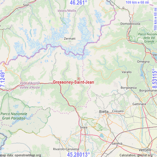
Gressoney-Saint-Jean GPS coordinates[2]
45° 46' 21.792" North, 7° 49' 40.872" East
| Map corner | latitude | longitude |
|---|---|---|
| Upper-left | 46.261°, | 7.1249° |
| Center: | 45.77272°, | 7.82802° |
| Lower-right: | 45.28013°, | 8.53115° |
| Map W x H: | 109.1×109.1 km | = 67.8×67.8mi |
| max Lat: | 47.04031° ⇑15.5% North |
| Gressoney-Saint-Jean: | 45.77272° |
| min Lat: | ⇓84.5% South 35.50142° |
| min Long | Gressoney-Saint | max Long |
| 6.69888° | 7.82802° | 18.48682° |
| W 4.7%⇐ | ⇒95.3% E |
Elevation
Elevation of Gressoney-Saint-Jean is 1383 m = 4537 ft, and this is 1076.3 m = 3531 ft above average elevation for this country.
| Max E: |
2085 m = 6841 ft | 0.5% |
| Gressoney-Saint-Jean | 1383 m 4537 ft | |
| Avg. | 306.7 m = 1006 ft | |
Min E: |
-4 m = -13 ft | 99.5% |
See also: Italy elevation on elevation.city.
Geographical zone
Gressoney-Saint-Jean is located in North temperate zone (between Tropic of Cancer and the Arctic Circle). Distance of this North polar circle is 2311.7 km =1436.4 mi to North.| Distance of | km | miles | from Gressoney-Saint-Jean |
|---|---|---|---|
| North Pole | 4917.6 | 3055.7 | to North |
| Arctic Circle | 2311.7 | 1436.4 | to North |
| Tropic Cancer | 2483.5 | 1543.2 | to South |
| Equator | 5089.4 | 3162.4 | to South |


Nearby cities:
15 places around Gressoney-Saint-Jean: (largest is in red/bold)
• Alagna Valsesia
12.2 km =7.6 mi,  43°
43°
• Antagnod
11.7 km =7.3 mi,  293°
293°
• Ayas
11.8 km =7.3 mi, 293°
• Berriat
13.8 km =8.6 mi,  238°
238°
• Brusson
7.8 km =4.8 mi,  258°
258°
• Challand-Saint-Anselme
9.7 km =6 mi,  228°
228°
• Challand-Saint-Victor
13.2 km =8.2 mi, 226°
• Emarese
12 km =7.5 mi, 243°
• Gaby
7.9 km =4.9 mi,  147°
147°
• Gressoney-La-Trinitè
6.3 km =3.9 mi,  356°
356°
• Issime
9.9 km =6.2 mi,  168°
168°
• Piedicavallo
13.5 km =8.4 mi,  133°
133°
• Quincod
9.7 km =6 mi, 228°
• Riva Valdobbia
11.9 km =7.4 mi,  56°
56°
• Villa-Nabian
13.3 km =8.3 mi, 226°
Sources, notices
• [Note1] Compared only with cities in Italy existing in our database
• [Src1] Map data: © OpenStreetMap contributors (CC-BY-SA)
• [Src2] Other city data from geonames.org with taken over terms of usage.
• [Src3] Geographical zone / Annual Mean Temperature by Robert A. Rohde @ Wikipedia
