Quincod geodata
Quincod (Aosta Valley) is a seat of a third-order administrative division; located in Italy in Europe/Rome (GMT+2) time zone. With population of 278 people, there are 10762 cities with bigger population in this country. Compared to other cities in Italy, 81.9% of cities are located further ↓South; 96.1% of cities are located further →East and 97.5% of cities have lower elevation than Quincod. Note1
Administrative division(s):
- Level 1: Aosta Valley
- Level 2: Valle d'Aosta
- Level 3: Challand-Saint-Anselme


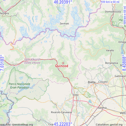
Quincod GPS coordinates[2]
45° 42' 54.468" North, 7° 44' 5.82" East
| Map corner | latitude | longitude |
|---|---|---|
| Upper-left | 46.20391°, | 7.03183° |
| Center: | 45.71513°, | 7.73495° |
| Lower-right: | 45.22203°, | 8.43808° |
| Map W x H: | 109.2×109.2 km | = 67.9×67.9mi |
| max Lat: | 47.04031° ⇑18.1% North |
| Quincod: | 45.71513° |
| min Lat: | ⇓81.9% South 35.50142° |
| min Long | Quincod | max Long |
| 6.69888° | 7.73495° | 18.48682° |
| W 3.9%⇐ | ⇒96.1% E |
Elevation
Elevation of Quincod is 1048 m = 3438 ft, and this is 741.3 m = 2432 ft above average elevation for this country.
| Max E: |
2085 m = 6841 ft | 2.5% |
| Quincod | 1048 m 3438 ft | |
| Avg. | 306.7 m = 1006 ft | |
Min E: |
-4 m = -13 ft | 97.5% |
See also: Italy elevation on elevation.city.
Geographical zone
Quincod is located in North temperate zone (between Tropic of Cancer and the Arctic Circle). Distance of this North polar circle is 2318.1 km =1440.4 mi to North.| Distance of | km | miles | from Quincod |
|---|---|---|---|
| North Pole | 4924 | 3059.6 | to North |
| Arctic Circle | 2318.1 | 1440.4 | to North |
| Tropic Cancer | 2477.1 | 1539.2 | to South |
| Equator | 5083 | 3158.4 | to South |


Nearby cities:
15 places around Quincod: (largest is in red/bold)
• Arnad
7.7 km =4.8 mi,  190°
190°
• Berriat
4.6 km =2.9 mi,  259°
259°
• Brusson
4.9 km =3 mi,  354°
354°
• Challand-Saint-Anselme
0.1 km =0.1 mi,  208°
208°
• Challand-Saint-Victor
3.6 km =2.2 mi,  220°
220°
• Champdepraz
6.9 km =4.3 mi,  241°
241°
• Emarese
3.7 km =2.3 mi,  287°
287°
• Gressoney-Saint-Jean
9.7 km =6 mi,  48°
48°
• Issime
9.8 km =6.1 mi,  109°
109°
• Issogne
7.7 km =4.8 mi, 209°
• La Place
7.8 km =4.8 mi, 210°
• Montjovet
4.8 km =3 mi, 260°
• Saint-Vincent
7.8 km =4.8 mi,  300°
300°
• Verres
6.5 km =4 mi, 213°
• Villa-Nabian
3.7 km =2.3 mi, 219°
Sources, notices
• [Note1] Compared only with cities in Italy existing in our database
• [Src1] Map data: © OpenStreetMap contributors (CC-BY-SA)
• [Src2] Other city data from geonames.org with taken over terms of usage.
• [Src3] Geographical zone / Annual Mean Temperature by Robert A. Rohde @ Wikipedia
