Berriat geodata
Berriat (Aosta Valley) is a seat of a third-order administrative division; located in Italy in Europe/Rome (GMT+2) time zone. With population of 582 people, there are 9160 cities with bigger population in this country. Compared to other cities in Italy, 81.6% of cities are located further ↓South; 96.5% of cities are located further →East and 69.4% of cities have lower elevation than Berriat. Note1


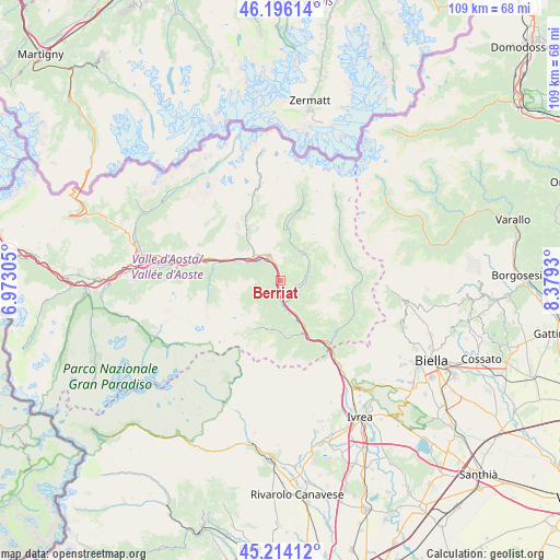
Berriat GPS coordinates[2]
45° 42' 26.244" North, 7° 40' 34.212" East
| Map corner | latitude | longitude |
|---|---|---|
| Upper-left | 46.19614°, | 6.97305° |
| Center: | 45.70729°, | 7.67617° |
| Lower-right: | 45.21412°, | 8.3793° |
| Map W x H: | 109.2×109.2 km | = 67.9×67.9mi |
| max Lat: | 47.04031° ⇑18.4% North |
| Berriat: | 45.70729° |
| min Lat: | ⇓81.6% South 35.50142° |
| min Long | Berriat | max Long |
| 6.69888° | 7.67617° | 18.48682° |
| W 3.5%⇐ | ⇒96.5% E |
Elevation
Elevation of Berriat is 389 m = 1276 ft, and this is 82.3 m = 270 ft above average elevation for this country.
| Max E: |
2085 m = 6841 ft | 30.6% |
| Berriat | 389 m 1276 ft | |
| Avg. | 306.7 m = 1006 ft | |
Min E: |
-4 m = -13 ft | 69.4% |
See also: Italy elevation on elevation.city.
Geographical zone
Berriat is located in North temperate zone (between Tropic of Cancer and the Arctic Circle). Distance of this North polar circle is 2319 km =1441 mi to North.| Distance of | km | miles | from Berriat |
|---|---|---|---|
| North Pole | 4924.9 | 3060.2 | to North |
| Arctic Circle | 2319 | 1441 | to North |
| Tropic Cancer | 2476.3 | 1538.7 | to South |
| Equator | 5082.2 | 3157.9 | to South |


Nearby cities:
15 places around Berriat: (largest is in red/bold)
• Arnad
7.4 km =4.6 mi,  154°
154°
• Brusson
7.1 km =4.4 mi,  35°
35°
• Challand-Saint-Anselme
4.6 km =2.9 mi,  79°
79°
• Challand-Saint-Victor
2.9 km =1.8 mi,  130°
130°
• Champdepraz
2.9 km =1.8 mi,  211°
211°
• Chatillon
6.6 km =4.1 mi,  315°
315°
• Emarese
2.2 km =1.4 mi,  28°
28°
• Issogne
5.9 km =3.7 mi,  172°
172°
• La Place
5.9 km =3.7 mi, 174°
• Lassolaz
7.6 km =4.7 mi,  297°
297°
• Montjovet
0.2 km =0.1 mi,  294°
294°
• Quincod
4.6 km =2.9 mi, 79°
• Saint-Vincent
5.3 km =3.3 mi,  335°
335°
• Verres
4.6 km =2.9 mi, 167°
• Villa-Nabian
3 km =1.9 mi, 131°
Sources, notices
• [Note1] Compared only with cities in Italy existing in our database
• [Src1] Map data: © OpenStreetMap contributors (CC-BY-SA)
• [Src2] Other city data from geonames.org with taken over terms of usage.
• [Src3] Geographical zone / Annual Mean Temperature by Robert A. Rohde @ Wikipedia
