Ghirla geodata
Ghirla (Lombardy) is a populated place; located in Italy in Europe/Rome (GMT+2) time zone. With population of 777 people, there are 7779 cities with bigger population in this country. Compared to other cities in Italy, 89.9% of cities are located further ↓South; 83.8% of cities are located further →East and 75% of cities have lower elevation than Ghirla. Note1


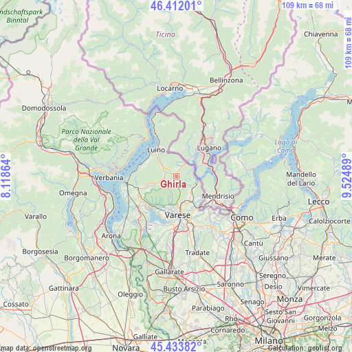
Ghirla GPS coordinates[2]
45° 55' 30.252" North, 8° 49' 18.336" East
| Map corner | latitude | longitude |
|---|---|---|
| Upper-left | 46.41201°, | 8.11864° |
| Center: | 45.92507°, | 8.82176° |
| Lower-right: | 45.43382°, | 9.52489° |
| Map W x H: | 108.8×108.8 km | = 67.6×67.6mi |
| max Lat: | 47.04031° ⇑10.1% North |
| Ghirla: | 45.92507° |
| min Lat: | ⇓89.9% South 35.50142° |
| min Long | Ghirla | max Long |
| 6.69888° | 8.82176° | 18.48682° |
| W 16.2%⇐ | ⇒83.8% E |
Elevation
Elevation of Ghirla is 451 m = 1480 ft, and this is 144.3 m = 473 ft above average elevation for this country.
| Max E: |
2085 m = 6841 ft | 25% |
| Ghirla | 451 m 1480 ft | |
| Avg. | 306.7 m = 1006 ft | |
Min E: |
-4 m = -13 ft | 75% |
See also: Italy elevation on elevation.city.
Geographical zone
Ghirla is located in North temperate zone (between Tropic of Cancer and the Arctic Circle). Distance of this North polar circle is 2294.8 km =1425.9 mi to North.| Distance of | km | miles | from Ghirla |
|---|---|---|---|
| North Pole | 4900.7 | 3045.2 | to North |
| Arctic Circle | 2294.8 | 1425.9 | to North |
| Tropic Cancer | 2500.5 | 1553.7 | to South |
| Equator | 5106.4 | 3173 | to South |


Nearby cities:
15 places around Ghirla: (largest is in red/bold)
• Bedero Valcuvia
2.6 km =1.6 mi,  232°
232°
• Cadegliano-Viconago
4.2 km =2.6 mi,  23°
23°
• Cassano Valcuvia
4.2 km =2.6 mi,  281°
281°
• Cavagnano
4.4 km =2.7 mi,  119°
119°
• Cuasso al Monte
4.6 km =2.9 mi,  104°
104°
• Cugliate-Fabiasco
2.3 km =1.4 mi,  353°
353°
• Cunardo
1.5 km =0.9 mi,  313°
313°
• Ferrera di Varese
2.7 km =1.7 mi,  288°
288°
• Ganna
2.6 km =1.6 mi,  172°
172°
• Grantola
4.5 km =2.8 mi, 306°
• Marchirolo
2.7 km =1.7 mi, 19°
• Marzio
3.2 km =2 mi,  62°
62°
• Masciago Primo
3.2 km =2 mi,  255°
255°
• Rancio Valcuvia
4 km =2.5 mi, 255°
• Valganna
2.5 km =1.6 mi,  177°
177°
Sources, notices
• [Note1] Compared only with cities in Italy existing in our database
• [Src1] Map data: © OpenStreetMap contributors (CC-BY-SA)
• [Src2] Other city data from geonames.org with taken over terms of usage.
• [Src3] Geographical zone / Annual Mean Temperature by Robert A. Rohde @ Wikipedia
