Cugliate-Fabiasco geodata
Cugliate-Fabiasco (Lombardy) is a seat of a third-order administrative division; located in Italy in Europe/Rome (GMT+2) time zone. With population of 2,873 people, there are 3141 cities with bigger population in this country. Compared to other cities in Italy, 90.5% of cities are located further ↓South; 83.9% of cities are located further →East and 77.8% of cities have lower elevation than Cugliate-Fabiasco. Note1
Administrative division(s):
- Level 1: Lombardy
- Level 2: Provincia di Varese
- Level 3: Cugliate-Fabiasco


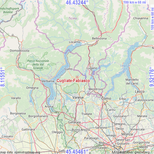
Cugliate-Fabiasco GPS coordinates[2]
45° 56' 44.448" North, 8° 49' 7.068" East
| Map corner | latitude | longitude |
|---|---|---|
| Upper-left | 46.43244°, | 8.11551° |
| Center: | 45.94568°, | 8.81863° |
| Lower-right: | 45.45461°, | 9.52176° |
| Map W x H: | 108.7×108.7 km | = 67.5×67.5mi |
| max Lat: | 47.04031° ⇑9.5% North |
| Cugliate-Fabiasco: | 45.94568° |
| min Lat: | ⇓90.5% South 35.50142° |
| min Long | Cugliate-Fabias | max Long |
| 6.69888° | 8.81863° | 18.48682° |
| W 16.1%⇐ | ⇒83.9% E |
Elevation
Elevation of Cugliate-Fabiasco is 490 m = 1608 ft, and this is 183.3 m = 601 ft above average elevation for this country.
| Max E: |
2085 m = 6841 ft | 22.2% |
| Cugliate-Fabiasco | 490 m 1608 ft | |
| Avg. | 306.7 m = 1006 ft | |
Min E: |
-4 m = -13 ft | 77.8% |
See also: Italy elevation on elevation.city.
Geographical zone
Cugliate-Fabiasco is located in North temperate zone (between Tropic of Cancer and the Arctic Circle). Distance of this North polar circle is 2292.5 km =1424.5 mi to North.| Distance of | km | miles | from Cugliate-Fabiasco |
|---|---|---|---|
| North Pole | 4898.4 | 3043.7 | to North |
| Arctic Circle | 2292.5 | 1424.5 | to North |
| Tropic Cancer | 2502.8 | 1555.2 | to South |
| Equator | 5108.7 | 3174.4 | to South |


Nearby cities:
15 places around Cugliate-Fabiasco: (largest is in red/bold)
• Bedero Valcuvia
4.3 km =2.7 mi,  204°
204°
• Cadegliano-Viconago
2.5 km =1.6 mi,  51°
51°
• Cassano Valcuvia
4.2 km =2.6 mi,  249°
249°
• Cunardo
1.5 km =0.9 mi,  213°
213°
• Ferrera di Varese
2.7 km =1.7 mi,  237°
237°
• Ganna
4.9 km =3 mi,  173°
173°
• Ghirla
2.3 km =1.4 mi, 173°
• Grantola
3.4 km =2.1 mi,  276°
276°
• Lavena Ponte Tresa
3.8 km =2.4 mi, 51°
• Marchirolo
1.2 km =0.7 mi,  77°
77°
• Marzio
3.2 km =2 mi,  105°
105°
• Masciago Primo
4.2 km =2.6 mi,  223°
223°
• Mesenzana
4.2 km =2.6 mi, 278°
• Rancio Valcuvia
4.9 km =3 mi,  227°
227°
• Valganna
4.8 km =3 mi,  175°
175°
Sources, notices
• [Note1] Compared only with cities in Italy existing in our database
• [Src1] Map data: © OpenStreetMap contributors (CC-BY-SA)
• [Src2] Other city data from geonames.org with taken over terms of usage.
• [Src3] Geographical zone / Annual Mean Temperature by Robert A. Rohde @ Wikipedia
