Ghedi geodata
Ghedi (Lombardy) is a seat of a third-order administrative division; located in Italy in Europe/Rome (GMT+2) time zone. With population of 16,351 people, there are 556 cities with bigger population in this country. Compared to other cities in Italy, 70.3% of cities are located further ↓South; 65.3% of cities are located further →East and 72.5% of cities have higher elevation than Ghedi. Note1


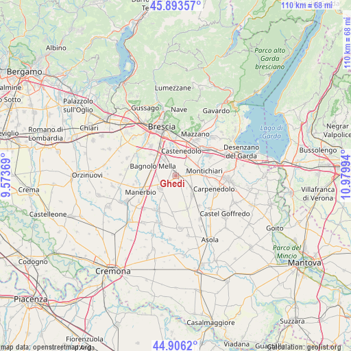
Ghedi GPS coordinates[2]
45° 24' 7.344" North, 10° 16' 36.516" East
| Map corner | latitude | longitude |
|---|---|---|
| Upper-left | 45.89357°, | 9.57369° |
| Center: | 45.40204°, | 10.27681° |
| Lower-right: | 44.9062°, | 10.97994° |
| Map W x H: | 109.8×109.8 km | = 68.2×68.2mi |
| max Lat: | 47.04031° ⇑29.7% North |
| Ghedi: | 45.40204° |
| min Lat: | ⇓70.3% South 35.50142° |
| min Long | Ghedi | max Long |
| 6.69888° | 10.27681° | 18.48682° |
| W 34.7%⇐ | ⇒65.3% E |
Elevation
Elevation of Ghedi is 85 m = 279 ft, and this is 221.7 m = 727 ft below average elevation for this country.
| Max E: |
2085 m = 6841 ft | 72.5% |
| Avg. | 306.7 m = 1006 ft | |
| Ghedi | 85 m = 279 ft | |
Min E: |
-4 m = -13 ft | 27.5% |
See also: Italy elevation on elevation.city.
Geographical zone
Ghedi is located in North temperate zone (between Tropic of Cancer and the Arctic Circle). Distance of this North polar circle is 2352.9 km =1462 mi to North.| Distance of | km | miles | from Ghedi |
|---|---|---|---|
| North Pole | 4958.8 | 3081.3 | to North |
| Arctic Circle | 2352.9 | 1462 | to North |
| Tropic Cancer | 2442.3 | 1517.6 | to South |
| Equator | 5048.2 | 3136.8 | to South |


Nearby cities:
15 places around Ghedi: (largest is in red/bold)
• Bagnolo Mella
7.6 km =4.7 mi,  291°
291°
• Bettole
9.8 km =6.1 mi,  357°
357°
• Borgosatollo
8.8 km =5.5 mi,  341°
341°
• Calvisano
8.1 km =5 mi,  140°
140°
• Capodimonte
7.3 km =4.5 mi,  353°
353°
• Castelletto
8.5 km =5.3 mi,  203°
203°
• Castenedolo
8.1 km =5 mi,  8°
8°
• Leno
5.9 km =3.7 mi,  232°
232°
• Montichiari
9.5 km =5.9 mi,  82°
82°
• Montirone
6.2 km =3.9 mi,  322°
322°
• Poncarale
10 km =6.2 mi,  310°
310°
• Porzano
6.3 km =3.9 mi,  269°
269°
• Sant'Antonio
6.2 km =3.9 mi,  87°
87°
• Viadana
5.7 km =3.5 mi,  125°
125°
• Vighizzolo
7.1 km =4.4 mi,  58°
58°
Sources, notices
• [Note1] Compared only with cities in Italy existing in our database
• [Src1] Map data: © OpenStreetMap contributors (CC-BY-SA)
• [Src2] Other city data from geonames.org with taken over terms of usage.
• [Src3] Geographical zone / Annual Mean Temperature by Robert A. Rohde @ Wikipedia
