Leno geodata
Leno (Lombardy) is a seat of a third-order administrative division; located in Italy in Europe/Rome (GMT+2) time zone. With population of 10,172 people, there are 934 cities with bigger population in this country. Compared to other cities in Italy, 69.4% of cities are located further ↓South; 65.8% of cities are located further →East and 76.8% of cities have higher elevation than Leno. Note1


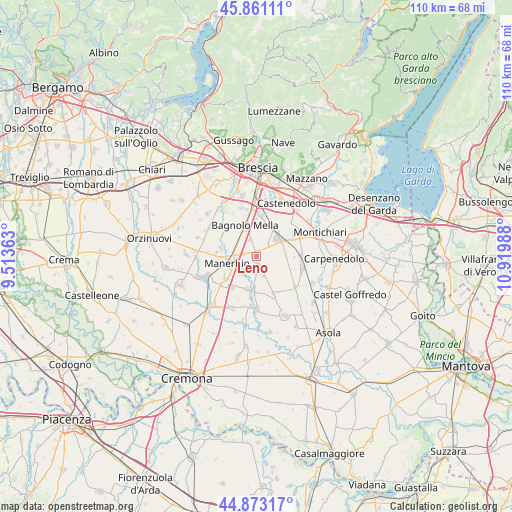
Leno GPS coordinates[2]
45° 22' 9.48" North, 10° 13' 0.3" East
| Map corner | latitude | longitude |
|---|---|---|
| Upper-left | 45.86111°, | 9.51363° |
| Center: | 45.3693°, | 10.21675° |
| Lower-right: | 44.87317°, | 10.91988° |
| Map W x H: | 109.8×109.8 km | = 68.2×68.2mi |
| max Lat: | 47.04031° ⇑30.6% North |
| Leno: | 45.3693° |
| min Lat: | ⇓69.4% South 35.50142° |
| min Long | Leno | max Long |
| 6.69888° | 10.21675° | 18.48682° |
| W 34.2%⇐ | ⇒65.8% E |
Elevation
Elevation of Leno is 65 m = 213 ft, and this is 241.7 m = 793 ft below average elevation for this country.
| Max E: |
2085 m = 6841 ft | 76.8% |
| Avg. | 306.7 m = 1006 ft | |
| Leno | 65 m = 213 ft | |
Min E: |
-4 m = -13 ft | 23.2% |
See also: Italy elevation on elevation.city.
Geographical zone
Leno is located in North temperate zone (between Tropic of Cancer and the Arctic Circle). Distance of this North polar circle is 2356.6 km =1464.3 mi to North.| Distance of | km | miles | from Leno |
|---|---|---|---|
| North Pole | 4962.5 | 3083.6 | to North |
| Arctic Circle | 2356.6 | 1464.3 | to North |
| Tropic Cancer | 2438.7 | 1515.3 | to South |
| Equator | 5044.6 | 3134.6 | to South |


Nearby cities:
15 places around Leno: (largest is in red/bold)
• Bagnolo Mella
6.9 km =4.3 mi,  339°
339°
• Bassano Bresciano
8.3 km =5.2 mi,  236°
236°
• Castelletto
4.4 km =2.7 mi,  162°
162°
• Cignano
8.8 km =5.5 mi,  272°
272°
• Cigole
7.2 km =4.5 mi,  197°
197°
• Corticelle Pieve
9.7 km =6 mi,  308°
308°
• Ghedi
5.9 km =3.7 mi,  52°
52°
• Gottolengo
9.4 km =5.8 mi,  154°
154°
• Manerbio
6.4 km =4 mi,  254°
254°
• Montirone
8.6 km =5.3 mi,  6°
6°
• Offlaga
8 km =5 mi,  282°
282°
• Pavone del Mella
7.6 km =4.7 mi,  184°
184°
• Porzano
3.9 km =2.4 mi, 335°
• San Gervasio Bresciano
8.8 km =5.5 mi,  218°
218°
• Viadana
9.3 km =5.8 mi,  88°
88°
Sources, notices
• [Note1] Compared only with cities in Italy existing in our database
• [Src1] Map data: © OpenStreetMap contributors (CC-BY-SA)
• [Src2] Other city data from geonames.org with taken over terms of usage.
• [Src3] Geographical zone / Annual Mean Temperature by Robert A. Rohde @ Wikipedia
