Gerola Alta geodata
Gerola Alta (Lombardy) is a seat of a third-order administrative division; located in Italy in Europe/Rome (GMT+2) time zone. With population of 152 people, there are 11276 cities with bigger population in this country. Compared to other cities in Italy, 93.2% of cities are located further ↓South; 72.6% of cities are located further →East and 97.6% of cities have lower elevation than Gerola Alta. Note1


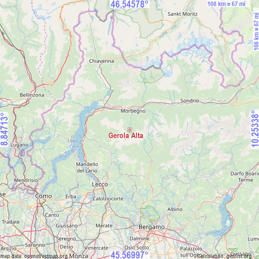
Gerola Alta GPS coordinates[2]
46° 3' 36.108" North, 9° 33' 0.9" East
| Map corner | latitude | longitude |
|---|---|---|
| Upper-left | 46.54578°, | 8.84713° |
| Center: | 46.06003°, | 9.55025° |
| Lower-right: | 45.56997°, | 10.25338° |
| Map W x H: | 108.5×108.5 km | = 67.4×67.4mi |
| max Lat: | 47.04031° ⇑6.8% North |
| Gerola Alta: | 46.06003° |
| min Lat: | ⇓93.2% South 35.50142° |
| min Long | Gerola Alta | max Long |
| 6.69888° | 9.55025° | 18.48682° |
| W 27.4%⇐ | ⇒72.6% E |
Elevation
Elevation of Gerola Alta is 1058 m = 3471 ft, and this is 751.3 m = 2465 ft above average elevation for this country.
| Max E: |
2085 m = 6841 ft | 2.4% |
| Gerola Alta | 1058 m 3471 ft | |
| Avg. | 306.7 m = 1006 ft | |
Min E: |
-4 m = -13 ft | 97.6% |
See also: Italy elevation on elevation.city.
Geographical zone
Gerola Alta is located in North temperate zone (between Tropic of Cancer and the Arctic Circle). Distance of this North polar circle is 2279.8 km =1416.6 mi to North.| Distance of | km | miles | from Gerola Alta |
|---|---|---|---|
| North Pole | 4885.7 | 3035.8 | to North |
| Arctic Circle | 2279.8 | 1416.6 | to North |
| Tropic Cancer | 2515.5 | 1563.1 | to South |
| Equator | 5121.4 | 3182.3 | to South |


Nearby cities:
15 places around Gerola Alta: (largest is in red/bold)
• Albaredo
5.7 km =3.5 mi,  33°
33°
• Bema
5.5 km =3.4 mi,  11°
11°
• Campovico
10 km =6.2 mi,  17°
17°
• Cosio Valtellino
8.3 km =5.2 mi,  0°
0°
• Cusio
8.7 km =5.4 mi,  152°
152°
• Morbegno
8.8 km =5.5 mi, 12°
• Ornica
8.2 km =5.1 mi,  164°
164°
• Pedesina
2.4 km =1.5 mi,  358°
358°
• Rasura
4.5 km =2.8 mi, 2°
• Regoledo
8.1 km =5 mi, 357°
• Rogolo
9.9 km =6.2 mi,  329°
329°
• Santa Brigida
10 km =6.2 mi, 146°
• Talamona
10 km =6.2 mi, 28°
• Traona
9.8 km =6.1 mi,  352°
352°
• Valtorta
9.3 km =5.8 mi,  187°
187°
Sources, notices
• [Note1] Compared only with cities in Italy existing in our database
• [Src1] Map data: © OpenStreetMap contributors (CC-BY-SA)
• [Src2] Other city data from geonames.org with taken over terms of usage.
• [Src3] Geographical zone / Annual Mean Temperature by Robert A. Rohde @ Wikipedia
