Fratte geodata
Fratte (The Marches) is a populated place; located in Italy in Europe/Rome (GMT+2) time zone. With population of 944 people, there are 6897 cities with bigger population in this country. Compared to other cities in Italy, 55.8% of cities are located further ↑North; 62.7% of cities are located further ←West and 51.4% of cities have higher elevation than Fratte. Note1
Administrative division(s):
- Level 1: The Marches
- Level 2: Provincia di Pesaro e Urbino
- Level 3: Sassofeltrio


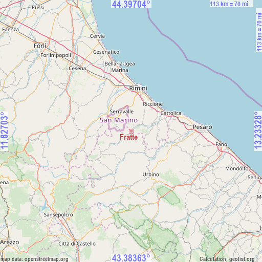
Fratte GPS coordinates[2]
43° 53' 32.964" North, 12° 31' 48.54" East
| Map corner | latitude | longitude |
|---|---|---|
| Upper-left | 44.39704°, | 11.82703° |
| Center: | 43.89249°, | 12.53015° |
| Lower-right: | 43.38363°, | 13.23328° |
| Map W x H: | 112.7×112.7 km | = 70×70mi |
| max Lat: | 47.04031° ⇑55.8% North |
| Fratte: | 43.89249° |
| min Lat: | ⇓44.2% South 35.50142° |
| min Long | Fratte | max Long |
| 6.69888° | 12.53015° | 18.48682° |
| W 62.7%⇐ | ⇒37.3% E |
Elevation
Elevation of Fratte is 225 m = 738 ft, and this is 81.7 m = 268 ft below average elevation for this country.
| Max E: |
2085 m = 6841 ft | 51.4% |
| Avg. | 306.7 m = 1006 ft | |
| Fratte | 225 m = 738 ft | |
Min E: |
-4 m = -13 ft | 48.6% |
See also: Italy elevation on elevation.city.
Geographical zone
Fratte is located in North temperate zone (between Tropic of Cancer and the Arctic Circle). Distance of this Northern Tropic circle is 2274.5 km =1413.3 mi to South.| Distance of | km | miles | from Fratte |
|---|---|---|---|
| North Pole | 5126.7 | 3185.6 | to North |
| Arctic Circle | 2520.8 | 1566.4 | to North |
| Tropic Cancer | 2274.5 | 1413.3 | to South |
| Equator | 4880.4 | 3032.5 | to South |


Nearby cities:
15 places around Fratte: (largest is in red/bold)
• Auditore
8.6 km =5.3 mi,  157°
157°
• Croce
5.9 km =3.7 mi,  53°
53°
• Falda
9.2 km =5.7 mi,  82°
82°
• Gemmano
4.3 km =2.7 mi,  72°
72°
• Mercatino Conca
4 km =2.5 mi,  231°
231°
• Monte Colombo
3.6 km =2.2 mi,  30°
30°
• Monte Grimano Terme
5.5 km =3.4 mi,  239°
239°
• Montefiore Conca
6.5 km =4 mi,  93°
93°
• Montescudo
2.9 km =1.8 mi,  17°
17°
• San Clemente
9 km =5.6 mi,  60°
60°
• San Savino
7.4 km =4.6 mi, 45°
• Sassofeltrio
1.6 km =1 mi,  268°
268°
• Taverna
3.1 km =1.9 mi,  44°
44°
• Tavoleto
7.4 km =4.6 mi,  136°
136°
• Trarivi
5 km =3.1 mi,  12°
12°
Sources, notices
• [Note1] Compared only with cities in Italy existing in our database
• [Src1] Map data: © OpenStreetMap contributors (CC-BY-SA)
• [Src2] Other city data from geonames.org with taken over terms of usage.
• [Src3] Geographical zone / Annual Mean Temperature by Robert A. Rohde @ Wikipedia
