Garlenda geodata
Garlenda (Liguria) is a seat of a third-order administrative division; located in Italy in Europe/Rome (GMT+2) time zone. With population of 957 people, there are 6838 cities with bigger population in this country. Compared to other cities in Italy, 54.4% of cities are located further ↑North; 92.3% of cities are located further →East and 77% of cities have higher elevation than Garlenda. Note1


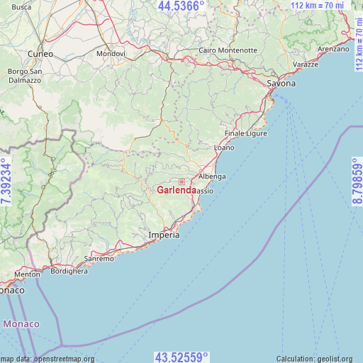
Garlenda GPS coordinates[2]
44° 1' 59.7" North, 8° 5' 43.656" East
| Map corner | latitude | longitude |
|---|---|---|
| Upper-left | 44.5366°, | 7.39234° |
| Center: | 44.03325°, | 8.09546° |
| Lower-right: | 43.52559°, | 8.79859° |
| Map W x H: | 112.4×112.4 km | = 69.8×69.8mi |
| max Lat: | 47.04031° ⇑54.4% North |
| Garlenda: | 44.03325° |
| min Lat: | ⇓45.6% South 35.50142° |
| min Long | Garlenda | max Long |
| 6.69888° | 8.09546° | 18.48682° |
| W 7.7%⇐ | ⇒92.3% E |
Elevation
Elevation of Garlenda is 64 m = 210 ft, and this is 242.7 m = 796 ft below average elevation for this country.
| Max E: |
2085 m = 6841 ft | 77% |
| Avg. | 306.7 m = 1006 ft | |
| Garlenda | 64 m = 210 ft | |
Min E: |
-4 m = -13 ft | 23% |
See also: Italy elevation on elevation.city.
Geographical zone
Garlenda is located in North temperate zone (between Tropic of Cancer and the Arctic Circle). Distance of this Northern Tropic circle is 2290.1 km =1423 mi to South.| Distance of | km | miles | from Garlenda |
|---|---|---|---|
| North Pole | 5111 | 3175.8 | to North |
| Arctic Circle | 2505.1 | 1556.6 | to North |
| Tropic Cancer | 2290.1 | 1423 | to South |
| Equator | 4896 | 3042.2 | to South |


Nearby cities:
15 places around Garlenda: (largest is in red/bold)
• Alassio
6.6 km =4.1 mi,  119°
119°
• Arnasco
5.1 km =3.2 mi,  10°
10°
• Bastia
6.7 km =4.2 mi,  66°
66°
• Casanova Lerrone
3.9 km =2.4 mi,  268°
268°
• Chiesa
5.1 km =3.2 mi, 12°
• Molino Nuovo
6.3 km =3.9 mi,  154°
154°
• Onzo
5.4 km =3.4 mi,  319°
319°
• Ortovero
2.3 km =1.4 mi, 8°
• Pian Rosso-Costa
4.9 km =3 mi,  156°
156°
• Rossi
4.7 km =2.9 mi,  218°
218°
• Stellanello
4.7 km =2.9 mi, 217°
• Testico
6.3 km =3.9 mi,  240°
240°
• Vendone
5.2 km =3.2 mi,  338°
338°
• Villafranca
0.8 km =0.5 mi,  92°
92°
• Villanova d'Albenga
4.1 km =2.5 mi, 67°
Sources, notices
• [Note1] Compared only with cities in Italy existing in our database
• [Src1] Map data: © OpenStreetMap contributors (CC-BY-SA)
• [Src2] Other city data from geonames.org with taken over terms of usage.
• [Src3] Geographical zone / Annual Mean Temperature by Robert A. Rohde @ Wikipedia
